Friday, December 6, 2013

Rain ending tonight, Winter Storm Watch issued...

 The cold front has passed and temperatures are dropping tonight to the upper 30s with some rain. Saturday will be cloudy in the morning with some lingering showers then clearing with highs in near 40. Saturday night will be clear with temperatures in the mid 20s and sunday will feature the weather event of the week, the appearance of old man winter.
The National Weather service has issued a Winter Storm Watch for our region spanning from just west of DC into West Virginia. Main hazards include snow and sleet during the onset on Sunday changing to freezing rain before finally changing to rain by Monday morning as warm southerly flow from the south erodes the cold air over our region.

The National Weather Service Watch text below, bold and color added for emphasis
URGENT - WINTER WEATHER MESSAGE
NATIONAL WEATHER SERVICE BALTIMORE MD/WASHINGTON DC
233 PM EST FRI DEC 6 2013

DCZ001-MDZ004>007-009>011-013-014-016-VAZ039-040-042-050>057-501-
502-070345-
/O.EXB.KLWX.WS.A.0008.131208T1400Z-131209T1200Z/
DISTRICT OF COLUMBIA-FREDERICK MD-CARROLL-NORTHERN BALTIMORE-
HARFORD-MONTGOMERY-HOWARD-SOUTHERN BALTIMORE-PRINCE GEORGES-
ANNE ARUNDEL-CHARLES-MADISON-RAPPAHANNOCK-LOUDOUN-ORANGE-CULPEPER-
PRINCE WILLIAM/MANASSAS/MANASSAS PARK-FAIRFAX-
ARLINGTON/FALLS CHURCH/ALEXANDRIA-STAFFORD-SPOTSYLVANIA-
KING GEORGE-NORTHERN FAUQUIER-SOUTHERN FAUQUIER-
INCLUDING THE CITIES OF...WASHINGTON...FREDERICK...WESTMINSTER...
GAITHERSBURG...COLUMBIA...BALTIMORE...ANNAPOLIS...WALDORF...
LEESBURG...CULPEPER...MANASSAS...MANASSAS PARK...FAIRFAX...
ALEXANDRIA...FALLS CHURCH...FREDERICKSBURG...WARRENTON
233 PM EST FRI DEC 6 2013

...WINTER STORM WATCH IN EFFECT FROM SUNDAY MORNING THROUGH
MONDAY MORNING...

THE NATIONAL WEATHER SERVICE IN BALTIMORE MD/WASHINGTON HAS
ISSUED A WINTER STORM WATCH...WHICH IS IN EFFECT FROM SUNDAY
MORNING THROUGH MONDAY MORNING.

* PRECIPITATION TYPE...SNOW AND SLEET WILL CHANGE OVER TO FREEZING
  RAIN SUNDAY AFTERNOON. FREEZING RAIN IS EXPECTED TO LAST UNTIL
  LATE SUNDAY NIGHT OR MONDAY MORNING BEFORE CHANGING TO RAIN.

* ACCUMULATIONS...1 TO 2 INCHES OF SNOW AND SLEET AND A QUARTER
  INCH OR MORE OF ICE ACCUMULATION IS POSSIBLE.

* TIMING...SNOW AND SLEET ARE EXPECTED TO BEGIN SUNDAY MORNING. A
  CHANGEOVER TO FREEZING RAIN IS EXPECTED MIDDAY SUNDAY AND WILL
  CONTINUE INTO THE NIGHT BEFORE CHANGING OVER TO RAIN LATE SUNDAY
  NIGHT OR MONDAY MORNING.

* TEMPERATURES...AROUND 30 DEGREES.

* WINDS...LIGHT NORTHERLY WINDS.

* IMPACTS...HAZARDOUS TRAVEL CONDITIONS ARE PROBABLE DUE TO SLICK
  ROADS AND ICY CONDITIONS SUNDAY AND POSSIBLY INTO MONDAY.
  INCREASED POWER OUTAGES ARE POSSIBLE.

PRECAUTIONARY/PREPAREDNESS ACTIONS...

A WINTER STORM WATCH MEANS THERE IS A POTENTIAL FOR SIGNIFICANT
SNOW...SLEET...AND ICE ACCUMULATIONS THAT MAY IMPACT TRAVEL.
CONTINUE TO MONITOR THE LATEST FORECASTS.


The mixture of sleet and snow would be more dense than normal snow and would cool down the road surface more effectively leading to more accumulations. what is worrying is the ice. at last an quarter inch is possible, which means accumulation may exceed the 1/4 inch criteria for an ice storm. this will cause major headaches for travel and may cause power outages.Remember to stay safe  and heed all NWS warnings
Thanks for reading, 
-Alex


Thursday, December 5, 2013

Chances Increasing for some Wintery Precip

Current Radar
The Forecast:
Rain is still coming on Friday through early Saturday morning as the storm currently producing winter weather over the central US comes our way with .5 -1 inch of rain possible. Highs will be in the 50s on Friday ,dropping as a cold front pushed through. Saturday will be cloudy in the morning and then clearing, with highs in the low 40s as high pressure builds. 
Bristol, Oklahoma, which is near Tulsa, on the afternoon of December 5th
Saturday night we be mostly clear as temperatures drop below freezing and the next storm system approached on sunday morning, with a strong possibility of wintery mix of snow, freezing rain, and sleet that will change to rain on monday before possible ending with a little snow on Monday night.


Official NWS forecast
Sunday: Snow likely before 9am, then snow, freezing rain, and sleet likely between 9am and noon, then rain, freezing rain, and sleet after noon. High near 33. Chance of precipitation is 90%. New precipitation amounts between a half and three quarters of an inch possible.

Sunday Night: Snow, freezing rain, and sleet before 1am, then rain or freezing rain. Low around 32. Chance of precipitation is 80%.
-------------------------------------------------------------------------------------------------------------------------------------


 A new model, the NAM
Previously, I have been discussing the American GFS (Global Forecast System) model, the ECMWF (European Center for Medium Range Weather Forecasting) model, and the Canadian CMC/GEM (Global Environmental Multiscale) model. The image below is from the NAM (North American Mesoscale Model), which is a short range, higher resolution model that only forecasts weather over the lower 48. This model's increased resolution allows the rain/snow line to be pinpointed quite more accurately. Its shortfall is that it only forecasts for the US and tends to overestimate precipitation amounts. The NAM forecasts a winter storm from Saturday to Monday with a lot of freezing rain.


NAM Precipitation type at 10PM EST (03Z) on Sunday night
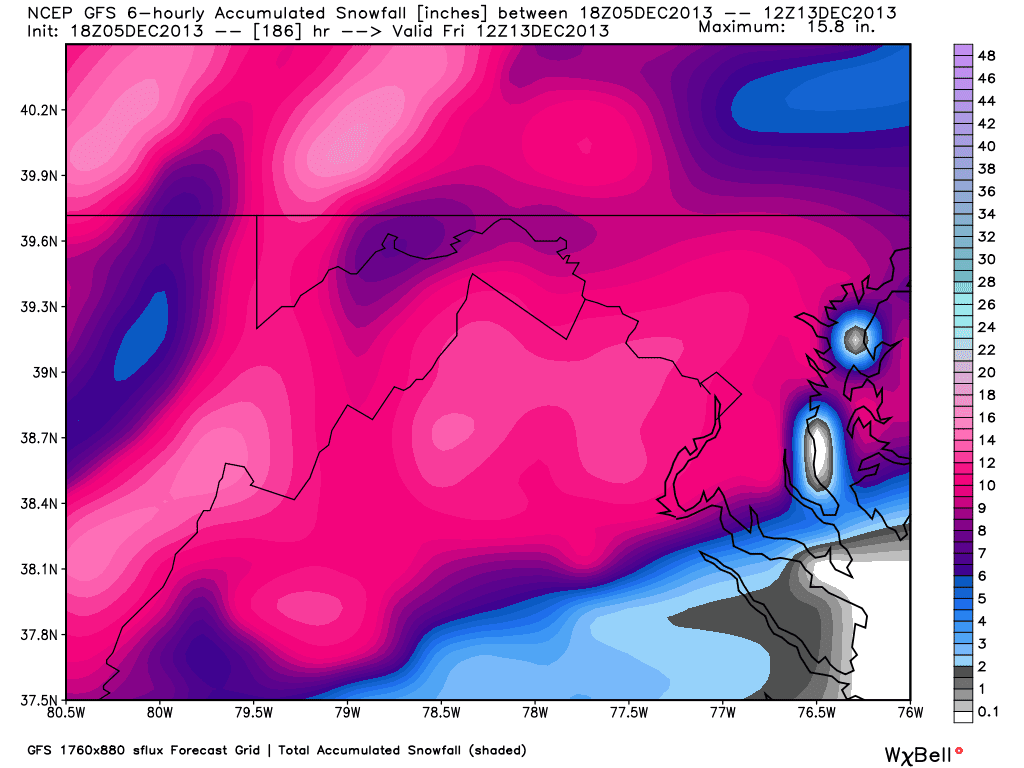
The 18z GFS run went nuts, giving us around a foot of snow. this is very unlikely to happen given the shallowness of the cold air mass and the storm track to the west of us.

Total precipitation (if all was liquid) forecast from the GFS


Winter storm Xaver impacting Europe
Winter storm Xaver is battering Northern Europe with heavy rain and high winds up to 160 kph (100mph). It has shut down all rail service to Scotland and killed a person in Scotland. In addition, the Glasgow train station was evacuated when debris shattered the glass roof.  Fortunately, Xaver brings a potent storm surge to an area that is well protected by levees so flooding danger is not especially high.

Source: http://www.dw.de/powerful-winter-storm-xaver-hits-scotland-germany-braces-for-its-arrival/a-17272948
Hamburg Fish Market flooded by the storm


Storm warnings for Germany. Pink indicates highest danger  and green indicates no danger

Measured wind gusts so far

Below is a video of Xaver battering the coast of Germany.


Test Post-Please disregard

This is where I will be testing out links, seeing if pictures will update automatically ect.
Saved image
Copied from site