Showing posts with label Tropics. Show all posts

Wednesday, February 22, 2017

Feburary Break is the new Spring Break

Winter may begin on December 1st of the 21st but one thing that meteorologists and the general public agrees is that February is still winter. That being said, February is the end of winter. That being said, I've heard that March is still winter in Ithaca. Well, after a long 3 weeks of second semester, I went back to the tropics of Maryland. Took a trip down to National Arboretum in DC to see spring come a month early. Every day over Break in DC was in the 70s. It was glorious.


The Japanese Apricots (Prunus mume) were in full bloom. They are the earliest blooming of the Prunus genus (cherry, peach, apricot, ect) There are probably hundreds of varieties out there, red pink, white, double, single, you name it. It's such a cute tree but not planted very often.
 The earlier camellias are actually done blooming. They've been lucky not to be wrecked by frosts (as if there have been any).
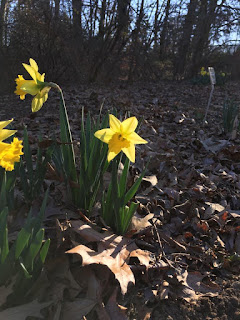


Elsewhere, the traditional spring flowers, Cornelian cherry (Cornus mas), top; Snowdrops on the left, and Daffodils on the right. In other garden news, the famous cherry blossom buds are starting. The peony buds are ready to pop. All they're waiting for is some persistent warmth. The forecast doesn't seem to want to drop temperatures below freezing for a while so the growing season is probably going to start for many plants, especailly those imported from areas less prone to large temperature swings (Asian Magnolias I'm looking at you). If that pans out, let's hope there are no late cold snaps. Otherwise we're going to get some unhappy gardens.

Tuesday, December 22, 2015

Happy Spring! er Winter! +Merry Torchmas

Happy Winter! Wait I already said that like 3 weeks ago... and then spring happened. Well December 1st marked the start of meteorological winter. The winter solstice (Dec 22 this year) marks the start of winter winter. However, the warmth is still not budging. After like 3 whole days of normal temperatures (Last Friday, Saturday, and Sunday), we have gone back to torching.

The pattern is remarkably predictable and consistent and just insanely warm. The Christmas Forecast I made last week still holds other than an upwards adjustment in temperatures. Temperatures will be in the 70s and may even approach 80 in spots with more clearing.

Date
Forecast Max/Min
Normal Max/Min
Records Challenged
Max/Min  Departure
12/24/2015
75/56
45/31
High Max 69(1933)
+30/+24
12/25/2015
67/51
44/31
High Min 49(1987)
+23/+20
12/26/2015
59/51
44/31
High Min 52 (1982)
+15/+20


High sky cover on the 24th may keep temperature down if it is thicker than expected.

We will probably break the record high on Christmas Eve (Thursday) before the cold front passes through in the evening. Temperatures will drop behind the front but will remain 15-20 degrees above normal. We also have chances to set record high minimum temperatures on the 24th (58), 25th (49) and 26th (52). With the warmth comes moisture and instability. There is a chance for gusty showers and perhaps even a thunderstorm during the day on the 24th ahead of the front. Any severe weather here would be extremely unlikely and unprecedented.

For now temperatures will likely stay warm for the rest of the year to place December 2015 as the warmest on record. After the New Year, there is hope that the miserably warm weather will go away. I'd like the plants to stay asleep in the ground right now anyway. I wish you a Merry Torchmas.


Wednesday, December 16, 2015

Winter gardening

 
Mid November:
Usually the banana is frosted back by the first week of November and wrapped by now. The leaves have been mildly frost damaged but the plant still looks good overall.
Musa Basjoo -Japanese Hardy Banana

The previous banana does not bear edible fruit. However, an unidentified banana flowered and bore fruit in late September. Despite the abnormal warmth, it isn't warm enough for the bananas to mature and ripen.


Blueberry plants showing they fall color as usual.

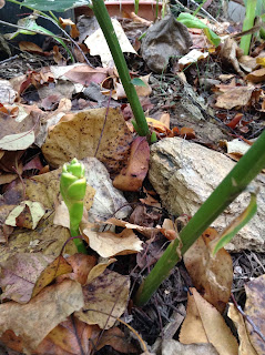
The edible ginger plants are still alive. They are zone 8 plants. One of them even managed to grow a flower (left photo).


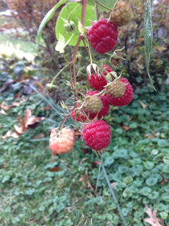
The Raspberry crop is still going. Fortunately, none of the wildlife in the neighborhood have found it tasty... yet...


Early December:
After a few additional frosts, the bananas have been beaten up. Frost damage is evident on the Musa basjoo. I usually wrap them up after the first hard frost. However, temperatures have not dropped below 31 degrees yet this winter so there is no need for protecting the plant. 

The edible banana plant was damaged too, more severely than the Musa basjoo.


Tuesday, December 15, 2015

Christmas Torchcast

It's warm. Like crazy warm. At least on the Eastern half of North America and it looks to stay that way through the end of the year at least. Sadly (or to your twisted joy), this may be the first December that no snow at all is recorded in this area since December 2001. Yes, even the horrible winter of 97-98 had snowfall (Trace). For the time being, the pattern doesn't show signs of much change through Christmas and the rest of winter break. The El-Nino is still raging and true cold air is nowhere to be seen. What happens after the new year remains to be seen.

The chances of a White Christmas are near zero. Instead, we can expect a beautiful day after a cold front clears through the night of Christmas Eve. Cold is relative. Highs on Christmas eve will be in the upper 60s to low 70s and highs on Christmas Day will be in the low to Mid 50s. Showers and maybe even a rumble of thunder may be possible on Christmas Eve.

Predicted temperatures at 1PM on Christmas Eve, 12/24/2015     
Temperature anomalies (16-20 degrees F) on Christmas Eve

Predicted temperatures at 1PM on Christmas Day, 12/25/2015

We are very confident that December 2015 will end up well above normal if not in record territory. The Climate Prediction Center, which issues Week 1 and Week 2 temperature forecasts (shown below), predicts that there is a very high chance,>90%, that the eastern half of the US will have above normal temperatures through the New Year. This may be the highest confidence the CPC has ever had for these forecasts.

Winter is basically nowhere to be found. The best chance of seeing cooler temperatures will be this weekend when a cold front arrives (of course, after . After that we go back to the torching just in time for Christmas :) Welcome to the Winterless Super-Nino of 2015...

Tuesday, December 1, 2015

Hello winter

Although by definition, meteorological winter begins today, you're going to have to wait quite a while before it's going to snow. In the DC area, winter doesn't really begin until January. Compound that with the strong El-Nino flooding the CONUS with mild pacific air, and viola, no snow. Temperatures in December are expected to remain well above average. The subtropical jet stream is also expected to crank up going into the winter so this month should be wet. In any case, it's not time to panic yet. If we enter mid January with no pattern change in site, then panic. Meanwhile, enjoy the warmth.

On a side note, check out this visualization of the abnormally warm sea surface temperatures in the Tropical Pacific associated with the El-Nino from earth.nullschool.net.