Today was a standard 2014 cold, dry, sunny day. DCA recorded a high of 23 at 12:00 AM, with temperatures dropping throughout the day due to continued cold air advection from behind the cold front.While we sit here and shiver, alaska is comparably balmy, even bordering on hot! Anchorage, Alaska recorded a high of 50 degrees today with light rain. While the polar air dominates our weather, record warmth has gripped the west and Alaska.
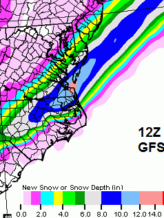
Tonight, as temperatures fall back into the lower teens, a winter storm, currently pounding the deep South with a mixed bag of frozen precip, approaches the area and may swipe us with a dusting to an inch of snow. anything more than an inch is very unlikely although computer models have been trending a tad north every run. Areas to the south and east have a higher chance of receiving any precip, with up to 2-3 inches of snow possible. Those to the north and west can expect cloudy skies and maybe a flurry or snow shower tonight amounting, at most, to a dusting. Tomorrow will be partly cloudy as the storm pulls out, with highs in the low 20s.Computer models:
The NAM gives us more precip, with 1-4 inches across the area both in the 12z and 18z runs. Notice the tight snow gradient

The 12z and 18z GFS gives us barely a dusting with the bulk of the snow to our south. Notice the very tight snow gradient characteristic of many snowstorms this year. As with the other storms, a track shift of 25 miles could result in a difference of a couple of inches either way.
This storm has already thrown some curveballs across the deep South. Traffic in Atlanta was thrown into a mess when 1-2 inches of unforecasted snow started falling around noon. Traffic mayhem ensued when unprepared motorists got caught in accidents in the snow. As stated before, the deep south has almost no capability to respond to winter weather due to the rarity of these events. Below are some images of the gridlock.
 |
| Progression of traffic while the snow falls. Green is good traffic and dark red is gridlock. |
 |
| Icicles in Mobile, Alabama where freezing rain and sleet fell |
Light snow is definitely possible off of this storm as it grazes us from the south. However, chances are not very high for anything greater than an inch. Beyond this, a warm up to near 50 and rain is forecast for the end of the week through the weekend before possibly cooling down again after.
Hope for snow and thanks for reading!
-Alex


No comments:
Post a Comment