Thursday, October 22, 2015

Hurricane Patricia: A "Potentially Catastrophic" Storm

October 23 2015 6:30 PM EDT Update:
Landfall... Weakened, but still very strong, although max winds will be confined to a very small area.
HURRICANE PATRICIA TROPICAL CYCLONE UPDATE
NWS NATIONAL HURRICANE CENTER MIAMI FL       EP202015
625 PM CDT FRI OCT 23 2015

...CATEGORY 5 HURRICANE PATRICIA MAKES LANDFALL ALONG THE COAST
OF MEXICO WITH 165-MPH WINDS...

Satellite images indicate that the center of the eye of Patricia
made landfall at approximately 615 PM CDT...2315 UTC...along the
coast of southwestern Mexico near Cuixmala.  This position is also
about 55 miles...85 km...west-northwest of Manzanillo, Mexico. The
maximum winds were estimated to be 165 mph...270 km/h.


SUMMARY OF 615 PM...2315 UTC...INFORMATION
---------------------------------------------------
LOCATION...19.4N 105.0W
ABOUT 55 MI...85 KM WNW OF MANZANILLO MEXICO
MAXIMUM SUSTAINED WINDS...165 MPH...270 KM/H
PRESENT MOVEMENT...NNE OR 15 DEGREES AT 14 MPH...22 KM/H
MINIMUM CENTRAL PRESSURE...920 MB...27.17 INCHES

$$
Forecaster Blake/Stewart

October 23 2015 5:00 PM EDT Update:
After the first pass, the Hurricane Hunters seemed to have suffered instrument issues and have been on standby outside of the storm for a good 2 hours. They are going in for the last pass as we speak. The storm seems to be in a weakening phase, with the eye rapidly contracting, which is good for the residents along the coast.


Radar image from the hurricane hunter aircraft showing the strong eyewall as well as a second, weaker eyewall outside


October 23 2015 10:00 AM EDT Update: 
Sunrise over the beast. 


October 23 2015 7:30 AM EDT Update: 
 Recon did a few more passes through the center before leaving last night. What they found was the strongest storm in the Western Hemisphere with a pressure of 880mb and maxiimum sustained winds of 200mph.


BULLETIN
HURRICANE PATRICIA ADVISORY NUMBER  14
NWS NATIONAL HURRICANE CENTER MIAMI FL       EP202015
400 AM CDT FRI OCT 23 2015

...PATRICIA...
...THE STRONGEST EASTERN NORTH PACIFIC HURRICANE ON RECORD...
...POTENTIALLY CATASTROPHIC LANDFALL IN SOUTHWESTERN MEXICO LATER
TODAY...


SUMMARY OF 400 AM CDT...0900 UTC...INFORMATION
----------------------------------------------
LOCATION...17.0N 105.5W
ABOUT 160 MI...255 KM SSW OF MANZANILLO MEXICO
ABOUT 235 MI...380 KM S OF CABO CORRIENTES MEXICO
MAXIMUM SUSTAINED WINDS...200 MPH...325 KM/H
PRESENT MOVEMENT...NNW OR 340 DEGREES AT 12 MPH...19 KM/H
MINIMUM CENTRAL PRESSURE...880 MB...25.99 INCHES

October 23 2015 1:30 AM EDT Update: 


October 23 2015 12:00 AM EDT Update: 
While we wait for recon to get into the storm, let's compare the current strongest storm to make landfall to Hurricane Patricia.

Supertyphoon Haiyan (2013)
Max Sustained winds of 195MPH
Min pressure of 895mb

Category 5 Hurricane Patricia
Current winds of 160MPH
Current pressure of 924 mb

October 22 2015 11:00 PM EDT Update: 
The hyperactive Pacific has done it. Patricia is now a  category 5 hurricane.
BULLETIN
HURRICANE PATRICIA ADVISORY NUMBER  12
NWS NATIONAL HURRICANE CENTER MIAMI FL       EP202015
1000 PM CDT THU OCT 22 2015

...POTENTIALLY CATASTROPHIC HURRICANE PATRICIA TURNING TOWARD
SOUTHWESTERN MEXICO...


SUMMARY OF 1000 PM CDT...0300 UTC...INFORMATION
-----------------------------------------------
LOCATION...16.2N 105.1W
ABOUT 200 MI...320 KM SSW OF MANZANILLO MEXICO
ABOUT 295 MI...470 KM S OF CABO CORRIENTES MEXICO
MAXIMUM SUSTAINED WINDS...160 MPH...260 KM/H
PRESENT MOVEMENT...NNW OR 330 DEGREES AT 10 MPH...17 KM/H
MINIMUM CENTRAL PRESSURE...924 MB...27.29 INCHES
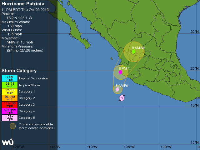
Projected Track of Hurricane Patricia brings it into the western coast of Mexico


October 22 2015 10:45 PM EDT Update:


Air Force Hurricane Hunter Reconnaissance is currently heading to investigate the storm. It is currently over Eastern Mexico and should enter the storm in the next hour. In the mean time, we are awaiting the official NHC advisory on Patricia which will come out around 11PM EDT. I am expecting an upgrade to a category 5 storm. The storm is still improving in satellite appearance with very cold cloudtops and an tiny eye.  This storm is a beast and is unfortunately headed right for Mexico.
Hurricane Patricia at 10PM October 22 2015


Original Text
Hurricane Patricia, the 20th storm in the East Pacific Basin of the 2015 hurricane system, has very rapidly strengthened over the past 36 hours. What was a minimal tropical storm yesterday off the Mexico coast has strengthened into a monster with estimated winds of 150 MPH. Earlier today, hurricane hunter aircraft entered the storm and measured winds over 130MPH. The storm has a nearly perfect structure, with abundant spiral banding and a pinhole eye surrounded by -70C cloudtops. This is an amazingly powerful storm and is forecast to hit the coast of Mexico as a strong major hurricane. Evacuations are ongoing on the west coast of Mexico, where there are many resort cities. Based on current satellite appearance, the storm probably will be upgraded to a category 5 later tonight.
Patricia popping out eye overnight October 21 2015 into the early morning hours of October 22 2015

Patricia's perfect ring of cold cloudtops around sunset October 22 2015

Monday, September 28, 2015

Tropical Storm Joaquin

Wednesday 9/30/2015 11:00PM  Update:
11:00PM advisory out. No change to track, max intensity adjusted up to 140mph, Category 4. 
 From the NHC:
...JOAQUIN BECOMES A CATEGORY 3 HURRICANE AS IT MOVES TOWARD THE CENTRAL BAHAMAS...
11:00 PM EDT Wed Sep 30
Location: 23.8N 73.1W
Moving: SW at 6 mph
Min pressure: 951 mb
Max sustained: 115 mph 

Wednesday 9/30/2015 10:00PM  Update:
Joaquin has been upgraded to a Hurricane and is currently impacting the Bahamas. It is currently rapidly intensifying. At 8:00 PM EDT, the NHC increased sustained winds to 105 mph (Category 2), about 10mph from major hurricane status. The ongoing Hurricane Hunter Mission has estimated winds over Category 3 strength. As a result, we expect the NHC to upgrade Joaquin to a major hurricane at 11:00PM EDT. Joaquin is currently meandering SSW near the Bahamas and has just recently popped out an eye. The NHC track brings it northwards on Friday and landfalls in SE Virginia late Saturday. This track should be shifted SW to reflect model consensus next advisory (11:00PM)
Models today have continued to trend southwards, with a landfall clustered around central North Carolina. That being said, there is still a lot of model spread. The European model, which is one of the best in the world, brings it out to sea. However, most models bend it into the East Coast.

To hopefully increase forecast consensus and accuracy, special weather balloon launches as well as hurricane hunter and other reconnaissance aircraft data will be inputted into the next model runs. We will be eagerly awaiting them. The bottom line is we are still not out of the woods. Even with a NC landfall, we could experience gusts up to 60 mph as well as heavy rain over the weekend into next week. Also, the storm could just as easily sift farther north. Until Joaquin begins it's northward turn, anything can happen.


Tuesday 9/29/2015 6:00PM  Update:
TS Joaquin broke a model...SENIOR DUTY METEOROLOGIST NWS ADMINISTRATIVE MESSAGE
NWS NCEP CENTRAL OPERATIONS COLLEGE PARK MD
2256Z TUE SEP 29 2015


18Z NAM UPDATE...

THE 18Z NAM FORECAST HAS PROGRESSED...GENERATING PRODUCTS OUT TO
T+57 BEFORE FAILING AGAIN. OUR TECH SUPPORT, ALONG WITH THE
MODEL DEVELOPER, BELIEVES THE ISSUE IS DUE TO HOW THE MODEL IS
HANDLING WATER TEMPERATURE NEAR TS JOAQUIN. THEY ARE CONTINUING
TO WORK TOWARDS A RESOLUTION ON THIS ISSUE. WE WILL KEEP YOU
POSTED. THANK YOU FOR YOUR PATIENCE.


Tuesday 9/29/2015 5:00PM  Update:
Well that was fast. Tropical Storm Joaquin has begun strengthening relatively quickly. This afternoon, the Hurricane Hunters measured a central pressure of 990mb and sustained winds up to 65 mph. Its cloud structure has improved since last night with deep convection covering the center of circulation although most of the convection is still confined to the south side of the storm due to persistent northwesterly shear.
The Future:
Tropical Storm Joaquin is expected to meander southwest for the next few days before turning northward as the upper level low out over the central US shifts eastward.

Monday 9/28/2015 Original Text:
Satellite imagery shows deep convection  with good outflow to the south. The Bahamas is on the bottom left
Tropical Depression 11, named last night, has sufficiently organized to be upgraded to Tropical Storm Joaquin.

Forecast Model runs (Dynamical+Statistical Early Cycle Models)
Official Track
Slow strengthening is forecast as it moves WSW towards the Bahamas before turning NNWwards towards the East Coast in response to a trough. Forecast models are still all over the place so the track is very uncertain. Stay alert for possible heavy rain and gusty winds this weekend.

Saturday, September 19, 2015

Winter 2015-2016: Pre-season Forecast

9/20/2015 9:45PM Update
Might as well add a table showing how I feel the winter will be like:
Overall December January Febuary
Temperatures Below Average well above average below average well below average
Precipitation: Well above average  above average above average well above average
Snowfall: Above average well below average normal well above average

The overall feeling is that of a backloaded winter as the El-Niño weakens and temperatures start cooling. Precipitation should remain above average for the duration of the winter. If we get snow, which is what I'm betting on, it will likely be the wet and heavy kind, with a chance of mixing. Remember, it only needs to be cold during 1 storm out of many rainstorms for us to get decent snowstorm.

I will actually take a close look at some data-sets during this week to hopefully tweak the chart and come up with some numerical values to the anomalies.

ORIGINAL TEXT:
To all the snowlovers out there: Do not write off the winter before it even starts. But do not get upset that we don;t have a month straight of snowcover this winter. We'll need a bit of luck to realize the full potential of this El-Niño Winter.

An El-Niño is generally defined as the presence persistent warmer than normal pool of water in the Central and East Pacific Ocean near the equator averaging.Typically, El-Niño result in a strengthened subtropical jet stream, which will bring pacific moisture laden storms across the southeast while the . In addition, during the winter, the northern parts of the country normally average on the warm side while the southeast stays cooler than normal due to all the storms. For us Mid-Atlantic peeps, we usually manage to stay around normal in temperatures while cashing in on increased precipitation. So we have a higher than normal chance of heavy snow right? If we can time storms with cold air.
Sea Surface Temperature Anomalies (red being positive) of the Pacific Ocean through late August
Computer model plume forecasts
A record breaking El-Niño is expected this winter. Our previous strongest El-Niño was in 1998. For the snow weenie's sake, let's not mention it. Following 1998's example we should expect to see is a good number of juicy southern jet storms.  The past couple of years, we've had the cold but not the moisture, which leads to the next factor, temperatures. Models have been hinting at a warm December, cooling down through January and February although they disagree on how much the cool-down will be. We need a few well timed cold shots to coincide with storms. We can't just blunder into storms like last year (we had a storm last year where we got 6 inches of snow while essentially sitting in the warm sector). This is where the 1998 example comes in (sorry snow lovers). That year, Pacific air flooded the southeast, resulting in washout after washout. DC recorded a total of 0.1 inches of snow. There was never any cold air. Of course this is just one example but it goes to say that luck is needed and some help from some other atmospheric events.
1998 Winter Temperatures and Precipitation Rankings (Shaded states are ones that had top 10s)

What gave us such amazing storms in 2009-2010 was the presence of extreme atmospheric blocking. Think about the jet stream as a highway, carrying storms along it. If it's straight, storms travel smoothly and quickly, AKA zonal flow, which is what has been dominating our winter for the past two years. Storms zip in and out within a day, dropping no more than a couple inches. To get blockbuster storms that crawl up the coast, one needs to induce kinks in the jet stream, bending it from Canada all the way to the Gulf Coast and back up again. This would be the result if a blocking High Pressure sets up near Greenland. When this happens, an index ( just a number based off of some calculations) call the North Atlantic Oscillation (NAO) will go negative. The more negative, the better. 09-10 was one of the most negative winters. Last year it was always positive. Blocking is somewhat correlated to El-Niños and already, the index and it's larger scale cousin, the Arctic Oscillation (AO) is forecasted to go negative soon, which is a welcome change. It will be something to watch this winter. More blocking=better chance at big snowstorms.


The AO forecast (red being all the individual forecasts of the ensemble)
The main takeaway is that we should be quite wet but temperatures and everything else remains to be seen since we are entering uncharted territory in terms of El-Niño effects. Do not expect a winter of frigid cold and many small snow events and we're going to be staring very closely at the AO and the NAO, looking for blocking. More likely than not, we will get big juicy storms where we're riding on the rain/snow line. We're going to go back to the old I-95 split unless we're as unlucky this year as 1998. Then I'm moving to New England.

I hope what I wrote made sense to those who are not as into this as me. I will probably update this post as I find time to cram in little details and explanations as well as hashing out all the factors and possible scenarios more thoroughly. If you have any questions, please ask.

Thanks for reading,
-Alex