Showing posts with label Snow. Show all posts

Saturday, March 18, 2017

An adventure through the snowstorm

Oh how I love snow. There's just nothing better than wandering through feet of snow as dendrites the size of half dollars pour out of the sky. Well that didn't quite happen but it came close. Anyways it's kind of hard to play in the snow if you can't walk and you can't see. I learned that in the 2010 snowstorms back in DC.

After classes were cancelled (of course after all my classes had let out already), I went sledding with friends and romping through the forest. From the hills beyond North Campus, I watched Cornell disappear into a shroud of snow.
Cornell's campus is somewhere back there I swear
At one point, night fell and since Wednesday had not been cancelled yet, went back to do work. Later that night, I got bored of work and decided to go for a walk in the blustery winter wonderland. Needless to say, trudging through 2-3ft snowdrifts was not easy. And to think that 2 weeks ago it had been pushing 70. Some of the early spring ephemerals had come out, especially in warmer microclimates around buildings. These were now buried under a protecting layer of snow. It's actually better than an exposed freeze. I've had plants freeze down to the snowline instead of the ground because snow is so insulating. That's why igloos work. Snow is great
You don't say...
Wind is the sculptor of snow. It brings the snow to life, swirling and drifting to form exquisite shapes. This is, however, not without the help of objects around it. Trees seem to sink into the ground and ripples flow across the paths.
Maybe it would be easier to just sled...


The solid barriers of buildings often create turbulence of on the lee side, scouring and depositing snow, creating unique twisted snowdrifts. This is why permeable windbreaks like trees work far better than walls. They slow the wind instead of deflect it. The drifts below were particularly eye-catching because they were. backlit by lights on the stairs between Roberts and Kennedy Hall.

Just above the stairs, the wind tunnel created by the buildings stripped all the snow away. Likewise, in exposed areas, the powdery was often stripped down to a couple of inches by the winds, even to bare ground at times. Cornell also kept the roads surprisingly open, probably with a ton of salt, which is an ecological issue in of itself. If only they could keep the sidewalks open too.

Central Campus at 1:30AM
The real reason I cam out was because I had spotted a lake effect band forming over Cayuga Lake and it meant business when it finally arrived. It was also almost 2:00AM and there were still people sledding down Libe slope, seemingly into a cloud of snowflakes. I presume this is why travel bans are a thing. It was really hard to see anything and it was cold so I went back...
Where's West?
Morrill Hall


In terms of snowfall, the blowing and drifting in addition to the localized nature of the snow bands made it hard to determine the snowfall amounts. An NWS employee measured 17.4" 1 mile NE of Ithaca, which would place it near Cornell's campus. Downtown Ithaca reported 14.7". Both reports were as the storm was winding down, but not yet completely over. Binghamton reported 31" of snow, breaking their all time storm total from the blizzard of 1993.First verified Winter Storm Warning since 2015. Let's see how the snowmelt goes in the March sun. With the big storms, warmups tend to come quickly after the storm. Overall, it was a pretty exciting storm. A big one for upstate NY definitely. But frankly, I do not expect that anything will beat the back to back blizzards in DC anytime soon in terms of raw power. I'd bet that those would also shut Cornell down for a week too.

Wednesday, March 15, 2017

March Monster

Look at the size of this beast of a storm. Its moisture feed stretches well into the Gulf of Mexico while it snows in upstate NY. This shows how weather connects the world's ecosystems. Water transpired by Caribbean plants are transported into the NE US to build snowpack, replenish rivers and aquifers, sustaining plant and animal communities up there too. And every once in a while, it gives Cornellians a day off.


Monday, March 13, 2017

Stating the obvious: Dont travel in a snowstorm

From the Binghamton NWS: "The CIPS analog system produces the Valentines day 2007 storm as the number one analog, and the 1993 superstorm as number 2. Both of these storms produced widespread 1 to 2 foot accumulations across our area with localized areas of 30+ inches."

Guess what... Cornell closed for both storms... Ithaca got 30" (all time record) in 1993 and 18" in 2007...

However, this time the warnings only suggest 10-18" inches of snow but the upside is much higher, in excess of 2 feet. Also the timing of the storm is bad, beginning early in the morning and going throughout the day. People might come to school but then may not be able to get back. I feel like this is a nightmare in the making. Of course the lower amounts could verify. We shall see....

Sunday, March 5, 2017

March Sun Angle


Ever since the winter solstice, the sun has been climbing higher and higher into the sky day by day. As we approach the equinox (and therefore spring, unless you're a meteorologist, the spring started when March did), the sun is getting stronger faster every day. One can feel the sun beating down on their backs now, especially near noon when the sun peaks at about 40 degrees in elevation. The higher the sun, the more direct the sunlight hits the surface of the Earth and the more energy is transferred.
 
An easy way to look at the energy of sunlight is to look at snowmelt patterns. The other day I noticed that the shadow of the trees were protecting snow from being zapped by the sun, even tracing out its major branches. Mind you it was in the mid 20s outside at the time this photo was taken. The sun at this point can easily warm the soil surface by 10 degrees F. This kind of freeze thaw typically does not go very deep but in the case where concrete or other heat absorbing materials are involved it can get interesting.
A Red Oak on Tower Road shelters some snow with its shadow.
One of my plant science professors Dr. Rossi once talked about how freeze thaw cycles induced by sun shining on concrete killed the grass around them. Grass around pavement really has a hard time. Foot traffic, salt, and heat all damage them. But his research showed that the sun does the killing, not the salt like many believed. The funny thing is at one point a critical amount of concrete is reached an one can have a consistent heating effect even at night and then you can zone push plants. Although Ithaca is officially zones 5b/6a, there are some small places, usually sheltered by well heated, concrete buildings that can harbor zone 6b or even zone 7a plants. It's all or nothing I guess.

Saturday, February 25, 2017

Back to our regular scheduled programming... Or is it now?

Well the cold front put a pause on our inevitable march towards spring. Over the course of the day we've gone from record warmth to slightly above normal temperatures. Today's high was in the low 60s and lows will probably dip to the mid 20s. Average high/low temperatures for 2/25 is 36/18 F.

In Ithaca, some days are like this...
Ideal morning walking conditions...
But some days we get this:
Early blooming Ranunculaceae at the Cornell Botanic Gardens...


Though I must say it is a bit early... Winter normally would have a firm grip well into March. Maybe we can score some seasonal weather after the next warm snap next week. Can 't really complain about this weather though...
Robin on the Ag Quad


Monday, February 6, 2017

Potential storm Wednesday night into Thurday

I just realized that it is the 7th anniversary of the Feb 2010 blizzards, AKA the best 2 weeks of our lives. Fun times. What I'd give for that again.


It's been a pretty nasty winter across the East for snowlovers. DCA is sitting at 1.4" for the season out of 2 snow events, both in January. Through out the winter, there have been signs of potential improvement in the  models but obviously we have been mislead. No reason to step away from that now. Winter basically never started. Although technically invalid, one could say that we are "due" for a below normal year. Maybe there is a connection. I'll leave that up to the real meteorologists to figure out.

Anyways.... Back to the forecast. After this cutter Tuesday, which should warm us well into the 60s, most of the global models (minus the Canadian) are suggesting that trailing energy will ride up along the front as weak low pressure, bringing precipitation over the area. Verbatim it's a nonevent for the immediate metro. There is a small chance that it will be snow in DC, slightly higher chances the farther north and west you go.  This is what the winter of 2017 has come to.
Forecasted temperatures for Tuesday afternoon
What we would need is for the storm to slow down and allow cold air in ahead of it. We never do well if we depend on cold air to come in on the back side. We also need it to trend a bit farther south. Both are pretty big things to ask for since we are only 3 days out. But considering that the Canadian has absolutely no storm in the same timeframe as all the other models. Who knows, we could get lucky.


CMC (Canadian) model
GFS (American ) model

Sunday, February 5, 2017

1/30-2/3 Alberta Clippers and Lake Effect Snow

Over the past week, it has snowed almost every day, which has been just awesome. This is one  of the reasons I like Ithaca. Ithaca averages between 60 and 70 inches of snow a year, although this year (and last) have been rather snow deprived. In addition, snowfall amounts vary greatly between the city central and the outlying areas due to elevation. Earlier during the winter, when it was warmer, I observed that the Animal Science area of campus would have snow accumulation while downtown would be just wet. I bet there probably is also the urban heat island effect at work too. But when it does snow (and stick), it provides a pretty scene.
So far, much of the snow has come from lake effect snow bands and weak low pressure systems called Alberta Clippers. My favorite snowflakes are what weather weenies call dendrites. Snowflakes actually come in many different shapes depending on the temperature and moisture available and dendrites are the mot beautiful of them all.
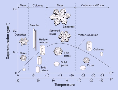
 Dendrites are what a typical person imagines a snowflake to be. However, snowflakes are often not that shape.  There are very specific conditions to the formation of dendrites and they are coveted by snow weenies for their beauty and their ability to accumulate quickly as very fluffy snow. Forming snow crystals is sort of like growing any other crystal. You have a seed where crystallization starts and slowly let the thing grow. The longer it stays the bigger and more complicated the crystal gets. With dendrites the optimal conditions are where temperatures in the cloud (called the snow growth region) are between -10 and -20 C and there is a relative abundance of moisture. Drier air results in thinner crystals and too dry results in needles as each of the arms break off. Too wet results in plates and thick snowflakes. It's all a balance.
Rather thick dendrite
Thinner dendrites

No matter what kind of snowflake falls, it's still pretty.

Looking at the East Ave. bridge over Fall Creek from the footbridge
Another thing that many people don't realize is that larger snowflakes are mostly aggregates of small snowflakes. Dendrites love to lock arms due to all the nooks in crannies in their structure. Another way of getting aggregates to to be rimed (have liquid water) since the water will help with sticking to each other (and other things). The snow that fell this week were not rimed. They were dendrites, as the closeups below show.

Aggregate snowflake
Many snowflakes
Exiting NTRES 2201 into a flurry of dendrites

Behind Mann

Construction of stormwater retention ponds on the Ag Quad
Temporary home of the Project Teams


Frozen Beebee Lake
Thus concludes my first place journal entry about the dendritic snowflakes of Ithaca. They are truely beautiful.
Just one more dendrite

Wednesday, January 25, 2017

January 23rd-24th Slopfest: First snow of the spring semester


What was progged to be a Winter Storm Warning level (6-10", first since 2015) thump of heavy wet snow fell short as an unusually persistent warm layer aloft turned the precipitation to rain. 33 and rain; I must have brought the curse of the Mid Atlantic up to Ithaca. Although delayed, the snow eventually did arrive, with rain turning to sleet and into snow by the early morning of the 24th. The result: 3-4 inches accumulation of sticky wet snow yielding a pretty winter scene.

Morning view in front of RPCC
Snow coated Dogwood tree
Honeylocusts coated with snow
Wet snow is sticky snow. At temperatures near freezing or when there is an overabundance of moisture, liquid water accumulates on the edge of the snowflake. The tendency of water to stick to things is called adhesion.
View in front of Clara Dickson Hall


Friday, November 18, 2016

Saturday through Tuesday Hybrid Lake-effect/Upslope Snow Event

Sunday 9:30 AM Update:
It snowed last night but then it all melted because we were 3 degrees above freezing. Areas just to the East of us will do much better due to elevation. Also there seems to be something about the topography that doesnt like Ithaca. Look at the Ithaca split on radar.

Still going with 3-6 inches total accumulation. Hopefully the bands will move around once we transition completely to Lake Effect Snow.

Saturday 7:44 AM Update:
We are still a go for snow. Models have generally converged to us getting around a half a foot of snow. Some will be lost to melting so accumulations will be lower. We are now in the range of multiple high resolution short range models. However, the event duration is too long for these models to cover the entire event. So we shall look at the 4 km resolution NAM again. You can see the lower totals over the finger lakes. This is both due to lower elevation and the moderating effect of the lake. Even then, Ithaca proper is forecasted to get 5 inches by the model. Let's see how much being 500ft above the lake helps us. It'll be a beautiful day for a bit. Enjoy it.

ORIGINAL TEXT
It might hit 70 tomorrow. And then 6 hours later it could be snowing. Time to bring up the memes again.

Tomorrow will be a nice late spring day. Temperatures will hit the mid to upper 60s by mid afternoo, possibly 70 thanks to a nice southerly breeze. By mid afternoon (3-4 pm), a strong cold front will be knocking on our doorstep. As the rain starts, temperatures will rapidly drop, as much as 20 degrees during the first hour as temperatures aloft crash. Depending on how fast the surface cools, rain could change over to a period of wet snow, after 9pm Saturday and continuing into the early morning hours.
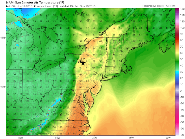
4km Resolution NAM depiction of temperatures across the Northeast at 2PM on Saturday. The front is about an hour out from Ithaca (black star) By 4PM, it is near 40.
Then a lull is expected as the synoptic scale activity and the lake effect/upslope snow machine cranks up Sunday morning. This situation is unique in that there is a large pool of cold air aloft associated with a strong upper level low (ULL) passing overhead Sunday. The cold air aloft makes it easier for the relatively warm air near the surface to rise (instability). In addition, the lower levels of the atmosphere will be moistened by relatively warm air being injected by the surface low pressure to our NE. This creates a ripe environment for multiple lake effect bands to develop unusually far away from the lake.
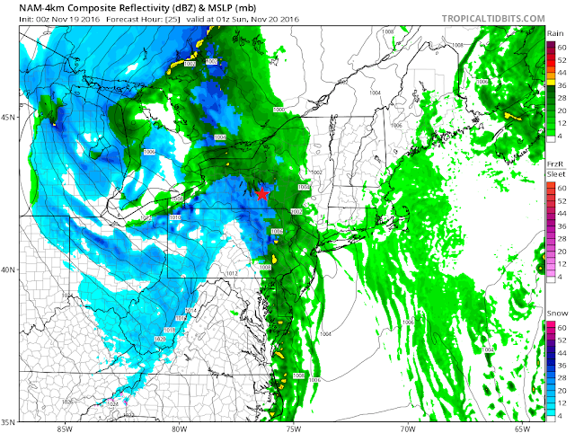
4km NAM showing a changeover to snow around 8PM. Typically, temperatures lag a bit compared to models so the changeover probably will be closer to 9 PM. This is still subject to change.
Since we are dealing with smaller scale bands, exact snow amounts are hard to predict and can range a lot over short distances but snowfall will be more widespread than usual due to the instability and moisture. Snowfall amounts will be greatest oh the hills directly to the south of Lake Ontario and Erie, with 8-12 inches of snow expected. In Ithaca proper, 2-3 inches of snow is forecasted by the NWS. On Cornell's campus, I expect 4-6 inches of snow since we are at a higher elevation. Snow amounts can easily exceed that if we are stuck under a snow band for a couple of hours, which I think is a possibility. It can also be under the forecast if the bands miss us. At that point it's not forecasting, it's nowcasting.
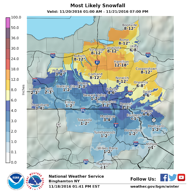
If you zoom in reeeeeally close, you can see the tight gradient between downtown and the hills we are on just east of downtown. Goes from 2-3 to 4-6 inches.
Winds after the front will initially be out of the NW at 20-25mph with gusts to 35mph Sunday dropping to the 10-15 mph range on Monday and Tuesday. Temperatures will be around freezing Sunday morning before dropping into the upper 20s Sunday night and mid 20s Monday night. Windchills could feel like the upper teens at times. Most of the snow should fall Sunday afternoon into Monday morning before diminishing into flurries by Tuesday morning. After Tuesday, it will be sunny and temperatures will begin a slow rebound before another system approaches late week. The impacts of that storm remains to be seen.
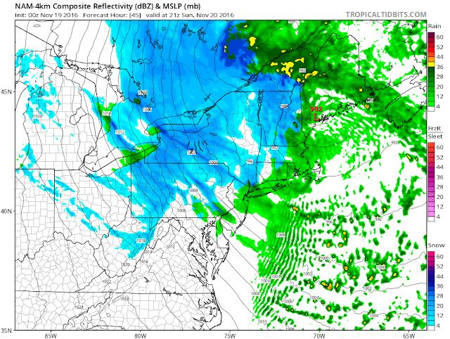
4km NAM showing lake effect bands with areas of upslope/ ULL enhanced snow.
This is just a summary of the situation for this weekend. There are too many things to write about here in detail-how topography affects snow amounts, why the lake effect bands even make it here, thundersnow potential, snow ratios,ect. In any case, if you like snow, yay! join the club. If not, at least it's not very cold and break is soon. Updates will be posted to this post so check back for them.

Thanks for reading!
-Alex