So without further ado, let's begin the march of the clown maps.
018Z Jan 19 2016 Cycle:
NAM
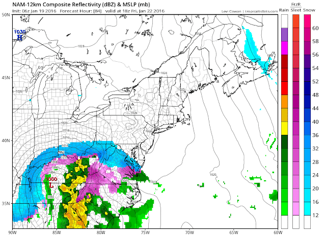
Gives us 16-18" of a front end dump before mixing issues due to an amped up storm-something the NAM is well known for doing. It's also not supposed to be used beyond 3 days (72hrs). Precip doesn't start until 72 hrs.
DGEX
AKA the NAM continued, is only useful for clown maps.
GFS
This run is honest;y a relief. The 12 Euro moved the storm south, leaving us on the northern edge of the storm. We were previously on the southern edge. The GFS has been remarkably consistent with bullseyeing the region and decided to keep doing that this run. It also sets up an deformation zone on the backside that dumps a lot of snow. Good run.
GEFS
Well it dropped south, but that puts us in the bullseye. Around 2 feet on the means. Min snow amount for DC is 6 inches. Maximum amounts are obscene. All I can say is that it'd be a pain to shovel.
12Z Jan 19 2016 Cycle:
GEFS
All big hits except for 3 that miss us to our south

GEFS Mean
21-24 inch mean. Enough said.

EPS Mean

06Z Jan 19 2016 Cycle:
NAM
We are finally in range of the mesoscale models. It's not going to be accurate at all at this point, but it's a milestone we have not reached all winter. All our previous storms died before d7 or so.
GFS
Fails to capture the upper level low resulting in a less amped storm. "Only" 20-25 inches,at least half of which is from the front end thump.
 GEFS
GEFSGEFS Mean
16-20 inches of snow across the whole area

00Z Jan 19 2016 Cycle:
GFS
Central MD Jackpot. Widespread 30"+
GEFS
GEM
20-30 inches of cold snow. No changeover

GEPS
16-18" of snow

ECMWF
Insane amounts of snow west. Probably not gonna verify, but fun to look at
18Z Jan 17 2016 Cycle:
DGEX
This is basically an extension of the NAM model which is a short range hi res mesoscale model. That should give you an idea on how right this map is. It actually suppresses the storm to the south. Also drops an absolutely ridiculous amount of precip/snow.
Clownmap Score: 9/10
Point taken off for not bulls-eyeing DC.
Points for showing an insane amount of precip, being the southernmost solution, screwing over the Northeast, and being the DGEX
GFS
American Model. Bullseyes DC with 21.8 inches of snow, well actually, bullseyes Fairfax City with 24+ inches.
Clownmap score: 9/10
Point taken off for outputting snowfall amounts that are even possible
Points for showing a bombing out low, DC bullseye, and a closed upper level low with extreme snowfall rates.
GEFS

12Z Jan 17 2016 Cycle:
GFS
GEFS
ECMWF
EPS
CMC
GEPS
UKMET


No comments:
Post a Comment