Wednesday, August 5, 2015

Restrengthening Typhoon Soudelor taking aim at Taiwan

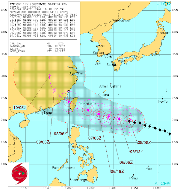
After a stint as the worlds strongest tropical cyclone this year so far, Typhoon Soudelor underwent an Eyewall Replacement Cycle (EWRC), allowing dry air to become entrained within the system. However, the storm seems to have overcome this problem and is rapidly reorganizing as it heads into warm waters around 30 degrees C and a favorable environment for intensification. It is forecast to chug west north westwards first through the heart of Taiwan, then into China. If it re intensifies, Soudelor could impact Taiwan as a category 4, or worse. Even if it does not, a category 3 strike would be quite damaging. Due to its mountainous terrain, extreme rainfall is common during typhoons as tropical moisture gets wrung out of the atmosphere. Landslides are common and flooding is likely.
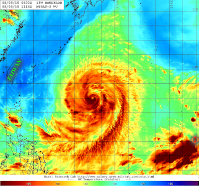
Water vapor image of Typhoon Soudelor showing excellent (near perfect) upper level outflow structure.
JTWC Forecast bring the typhoon right through the center of Taiwan

Although the storm is forecast to landfall dead center on Taiwan, Souledor is a large storm that will affect the whole island. That being said, the exposed eastern coast of the island is sparsely populated and the populated centers of Taipei and Kaohsiung are at the northern and southern tips of the island, respectively. Taiwan is commonly affected by typhoons and so its infrastructure has been engineered to withstand the forces of the storm. However, a strong typhoon will still be very damaging.
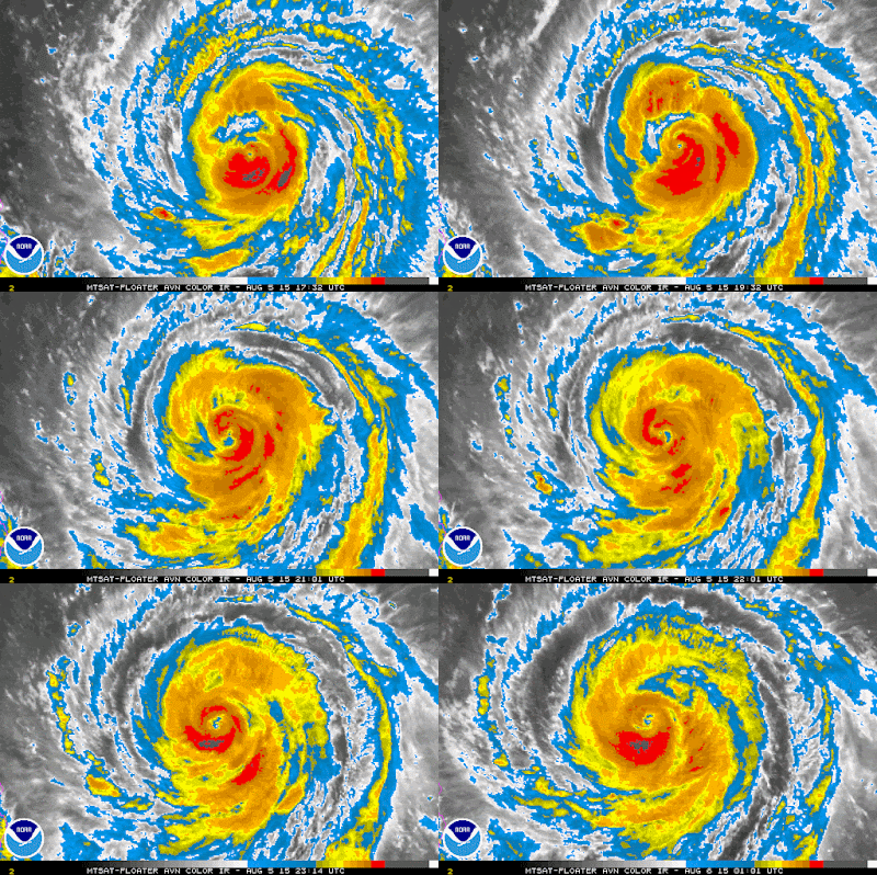
The typhoon is currently attempting to expel dry air from the core and rebuild its eyewall and begin the restrengthening process as it enters a more favorable environment.


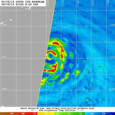
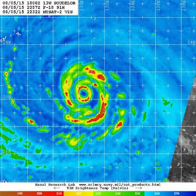
Soudelor had a break in the SE side of the eyewall due to the EWRC and because of dry air. This caused the storm to weaken to a Cat 3 with 115 MPH winds

A couple of hours later, the eyewall has been closed, IR satellite imagery (animation above) shows an increase of convection at this time too, signalling that the storm is strengthening and reorganizing. Notice how outside the eyewall, the convective bands seem to be forming a loop, when this loop closes, the storm may undergo another EWRC, hopefully before landfall.
Landfall on Taiwan is a blessing to China, which is less well prepared since the mountains will disrupt the storms circulation, significantly weakening the storm before it drifts into China. This storm will be closely watched as it approaches land over the next 48 hours-enough time for the storm to change drastically.

Monday, April 20, 2015

First Slight Risk of the year today


As the warm front that brought us about 1.5 inches of rain quickly lifts north, some clearing should occur quickly this morning.  This will allow temps to rise into the upper 70s and maybe lower 80s by mid afternoon if clearing is complete. 
 Storms are expected to develop ahead of an approaching cold front in the afternoon some storms may be severe and as a result the SPC has issued a slight risk for the Mid Atlantic region. They have hinted that they may upgrade our area later in the day.

...PORTIONS OF THE MID-ATLANTIC TO THE FL PENINSULA...  
THE OVERALL SYNOPTIC-SCALE PATTERN IS NOT FORECAST TO BE CONDUCIVE FOR DEFINITIVE SPATIOTEMPORAL OVERLAP OF DEEP ASCENT WITH STRONG MOISTURE RETURN/BUOYANCY...IN RESPONSE TO /1/ THE GROWING GAP BETWEEN THE NWD-TRACKING OCCLUDED CYCLONE CENTER AND RICHER TROPOSPHERIC MOISTURE RELEGATED TO THE SERN CONUS...AS WELL AS  /2/ THE PARENT MID-LEVEL CYCLONIC PERTURBATION BECOMING CLOSED.

   REGARDLESS...STRENGTHENING MID-LEVEL WLYS ACROSS THE SERN STATES WILL ENCOURAGE EWD ADVECTION OF AN EML PLUME SAMPLED BY SUNDAY EVENING RAOBS OVER THE SRN GREAT PLAINS...INTO PARTS OF THE SE CONUS/CAROLINAS. RELATED STEEP MID-LEVEL LAPSE RATES WILL OVERLIE UPPER 50S TO LOWER 60S SFC DEWPOINTS AHEAD OF THE FRONT. THIS SHOULD SUPPORT MLCAPE AROUND 1000-2000 J/KG BY PEAK HEATING WITH LITTLE MLCINH ACROSS THE SLIGHT-RISK AREA. THIS IS WHERE A DIURNAL INCREASE IN CONVECTIVE COVERAGE AND INTENSITY IS EXPECTED AMIDST MODEST FRONTAL CONVERGENCE AND TERRAIN-ENHANCED CIRCULATIONS. LONG...STRAIGHT LINE HODOGRAPHS MAY SUPPORT SPLITTING SUPERCELL  STRUCTURES INITIALLY...THOUGH AREAS OF LOCALIZED UPSCALE CONVECTIVE GROWTH INTO SEMI-ORGANIZED CONVECTIVE CLUSTERS ARE ANTICIPATED IN THE LOW-MLCINH ENVIRONMENT. ISOLATED TO SCATTERED SVR WIND/HAIL WILL BE LIKELY.

   MID-LEVEL HEIGHT FALLS WILL BE SOMEWHAT MORE PRONOUNCED ACROSS PARTS OF THE MID-ATLANTIC...AND SOMEWHAT GREATER SVR COVERAGE MAY OCCUR IN THIS REGION. THIS COULD WARRANT UPGRADE TO ENHANCED DESIGNATION IN SUBSEQUENT OUTLOOKS...AND A FEW ISOLATED INSTANCES OF SIGNIFICANT SVR HAIL ALSO CANNOT BE RULED OUT. HOWEVER...SUBSTANTIAL MID-LEVEL DRYING IN THE WAKE OF A LEAD DISTURBANCE PRESENTLY MOVING OVERHEAD PER WATER VAPOR IMAGERY...AND THE PRESENCE OF ONLY MODEST DEEP ASCENT OVER THE WARM SECTOR DURING PEAK HEATING...CAST TOO MUCH  DOUBT ON THE IDENTIFICATION OF CORRIDORS OF ENHANCED AND/OR SIGNIFICANT SVR POTENTIAL. ALSO...ONE OR TWO SHORT-LIVED TORNADOES CANNOT BE RULED OUT ACROSS THE SLIGHT-RISK AREA GIVEN ENHANCED LOW-LEVEL SHEAR BENEATH A LLJ. HOWEVER...THE OVERALL TENDENCY FOR SFC WINDS TO VEER THUS LIMITING 0-1-KM SRH ACROSS THE WARM SECTOR RENDERS MARGINAL TORNADO PROBABILITIES FOR THIS OUTLOOK. RELATIVELY MORE BACKED SFC WINDS MAY BE FOUND FROM PARTS OF MD/DC INTO CNTRL/ERN PA AT THE NRN EDGE OF THE WARM SECTOR/WARM FRONT...WHERE SOMEWHAT GREATER TORNADO POTENTIAL MAY EXIST. HOWEVER...DIURNAL GAINS IN BUOYANCY COULD BE STUNTED BY RESIDUAL CLOUDS RELATED TO THE LEAD DISTURBANCE...ONCE AGAIN RENDERING ONLY MARGINAL PROBABILITIES FOR TORNADO POTENTIAL. CONVECTION WILL BEGIN WEAKENING BY EVENING AS IT NEARS/MOVES OFF THE ATLANTIC COAST.

Wednesday, March 18, 2015

Misleading Title: Spring is here

2:00PM March 19th, 2015 Update: 
We are still a go for snow. Winter weather advisories have been issued for the northern part of Moco.
The updated Map has increased amounts of snow for us tomorrow. Maybe a delay is possible (45%).

Original Text
Meteorological spring started the moment March started. The weathermen say it's spring so it should warm up right? No more snow right? Nope. There is another day that spring starts on (vernal equinox), and this year it's on March 20th. View it like sorta a backup date, in case the weathermen get it wrong (we often do). However, despite our efforts to set boundaries for mother nature, winter will make periodic comebacks. Like on Friday, the (second) first day of "Spring" (Technically it starts at 6:46pm, when the Earth moves to some arbitrary set position along its orbit.)

Anyways back to the wet snow... or slush... white rain, snain, whatever... The point is frozen water will fall out of the sky on Friday. Another marginal event that trends slightly better. A standard weak CAD event with a retreating high that keeps just enough cold air in. Surface temps never get blow freezing so accumulations will be hard unless it snows hard, which is possible for a few hours in the early morning. This means that at least we got our timing right except that it's late March. There is likely to be 1-2 inches of slushy accumulation upcounty and up to an inch for the rest of us. Impacts are expected to be mild. An outside chance at a delay. The snow will be gone by Friday evening. The late March sun will fry it. Then it will be spring... or will it... the high will be in the 60s on Saturday at the very least.

The NWS forecast map: