Summary:
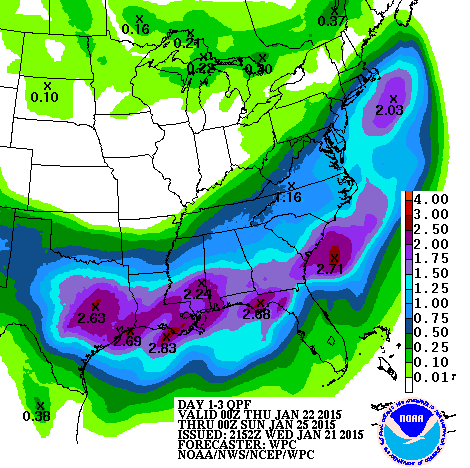
A shortwave trough over the southwest is expected to spawn a surface low in the Gulf of Mexico as it moves east. As the storm strengthens, it is expected to turn north, passing near the Outer Banks of North Carolina, and strengthen as it heads NE out to the North Atlantic. This storm will bring precipitation, possibly heavy, to the region. Precipitation type has yet to be determined due to the lack of cold air and uncertainties in storm track and strength.
 |
| Our future coastal storm traversing the Southwestern US (Nevada, Arizona, New Mexico area) this morning |
Discussion:
This storm will be very moisture laden, drawing up warm, moist air from the Gulf of Mexico and traveling north along the subtropical jet stream. These storms are know as Miller A type storms, and are well known for dropping high amounts of precipitation across the East Coast. Miller A snowstorms usually bring heavy, wet snow, just like the first storm of February 2010. This storm will not be as epic as that one though. However, this storm will be amped up, with pressures dropping possibly into the upper 980s ( about the pressure of a category 1 hurricane) by the time the storm starts pulling away.
The three ingredients for snow are cold, lift, and moisture. We have the moisture and lift, but cold will be marginal. Since we will lack a high pressure to the north, cold air will be residual. However, two possibly three things will benefit us. One is the presence of moderately cold air before the storm, the second is the midnight start time. There will be no daytime heating to deal with. The third is if the precipitation is heavy enough, dynamic cooling, will cool the air column. Temperatures are expected to be in the low 30s, but can change depending on storm strength and track.
Storm track and strength will affect temperatures both at the surface and aloft. Often, stronger coastal storms with a similar track will draw in warm air aloft, causing snow to mix or change over to sleet and or rain along the I-95 corridor. Mixing would majorly cut back on snow totals. Still worse is a track that is too far west, which draws even more warm air in, causing the storm to be all rain for us. As of now, it seems that the precipitation will at least start off as snow before mixing or changing over. Exact durations of frozen and liquid precipitation has yet to be resolved.
 |
| HPC preciptation forecast |
Summary:
In a marginal situation like this, many things can change in an instant. A couple of miles here and there can result in big changes. There is still a lot of model disagreement over precip timing, and amounts and storm track and strength. Maybe we rely on them too much. In any case, snow is possible Friday night into Saturday, and if not, it'll probably be rain. A complete miss seems unlikely.
Updates will come as warranted.
Thanks for reading!
-Alex
No comments:
Post a Comment