Jan 22 2016 9:00AM Update
Storm is coming. It's go-time. Storm evolution has not changed much: around 2 feet of snow will fall. Snow may come in a little earlier, like 1 or 2PM. Also, they did mention the chance of a dry-slot impacting us, cutting down on totals a bit. But we gotta live on the edge if we want to have a chance at jackpotting. Basically, people just to the west of the dry-slot will jackpot. Thundersnow is also possible. It's gonna be fun
Jan 22 2016 1:15 AM Update
On the most important Euro run of the year, it "s**ts the bed"
. The Euro got stuck at 12 hrs into the run. No graphics, only text outputs with missing data. Well I guess we can toss that run. 2+ feet of snow it is then.
CMWF Deterministic FORECAST FOR: DCA LAT= 38.85 LON= -77.03 ELE= 16
00Z JAN22
2 M 850 SFC SFC 700 6 HR 500 1000
TMP TMP PRS RHU RHU QPF HGT 500
© © (MB) (PCT) (PCT) (IN) (DM) THK
FRI 00Z 22-JAN -2.3 -7.7 1027 51 16 553 532
FRI 06Z 22-JAN -3.6 -7.1 1027 52 17 0.00 554 533
FRI 12Z 22-JAN -3.6 -6.2 1027 54 33 0.00 555 535
FRI 18Z 22-JAN ___ ___ ____ __ __ ____ ___ ___
SAT 00Z 23-JAN -4.0 -6.6 1019 86 99
____ 551 536
SAT 06Z 23-JAN -3.8 -3.9 1010 87 100 0.52 546 539
SAT 12Z 23-JAN -3.4 -5.1 1002 82 94 0.71 538 536
SAT 18Z 23-JAN -3.3 -5.9 1003 81 71 0.18 536 534
SUN 00Z 24-JAN -2.6 -7.0 1009 80 98 0.23 537 530
SUN 06Z 24-JAN -3.4 -5.1 1013 69 81 0.05 543 533
Jan 22, 2016 12:00AM Update:
I have a post to track the storm and it's progress. ths page will be used to post the forecast/nowcast.
http://mdtropics.blogspot.com/2016/01/the-life-of-storm.html
Jan 21 2016 11:00PM Update
The NWS increased snow totals and wind. 24-30" of snow, and sustained winds of 25-35mph with gusts up to 55. This is no longer a "fun" storm. This is an life threatening and historic event.
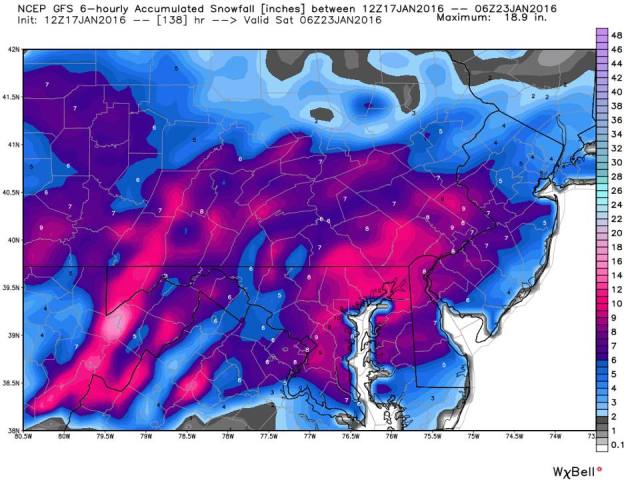
On the more interesting the most recent models have gone absolutely bonkers on the snowfall predictions tonight.
First up was the 4K hires NAM, which jackpotted western VA and northern MD with 30"+. This run was initially discounted due to its anomalously high precip amounts (a very NAM thing to do) The running joke is to take the NAM output and divide by 2 to get the actual result. Not true either, but the NAM does have a wet bias.
Then the RGEM (Canadian hires short term model). It has historically done pretty good forecasting mesoscale structures during winter storms. It sets up the deform band directly over DC, crushing us with upwards of 40" of snow, with a couple inches still to come. The main thing is that the low positions were very realistic-off the coast of Ocean city, that it is a hi-res model that is able to resolve mesoscale banding better than the global models like the GFS, and the fact that it has done well for the past few winters. The totals are just unrealistically high.
Then came the GFS, global model, with lower resolution. Imagine the surprise when it also dropped upwards of 36" across the DC area, similar to the RGEM. Holy smokes. The solution would probably have been immediately thrown out if RGEM didn't have the solution it has. The GFS probably are overdoing convective banding. The high totals may be more isolated, but the fact that the RGEM has it too gives one pause.
We shall see soon. Waiting on the Euro to either seal the deal, or break it.
Jan 21 2016 12:41 PM Update
We are in the home stretch. Our storm is forming in the gulf coast states and the models are locked in on around 2 feet of snow for the region
. The NWS has gone ahead an upgraded the watches to warnings as well as increasing snowfall forecasts.We are under a blizzard warning from Friday 3PM through the Saturday night. If you haven't finished preparing, please do so today.
 |
| Orange is the blizzard warning |
.BLIZZARD WARNING IN EFFECT FROM 3 PM FRIDAY TO 6 AM EST
SUNDAY...

THE NATIONAL WEATHER SERVICE IN BALTIMORE MD/WASHINGTON HAS
ISSUED A BLIZZARD WARNING...WHICH IS IN EFFECT FROM 3 PM FRIDAY
TO 6 AM EST SUNDAY. THE BLIZZARD WATCH IS NO LONGER IN EFFECT.

* HAZARD TYPES...HEAVY SNOW AND WIND WITH BLOWING AND DRIFTING
  SNOW FRIDAY AFTERNOON THROUGH SATURDAY NIGHT. SLEET MAY MIX WITH
  THE SNOW FRIDAY NIGHT INTO SATURDAY MORNING EAST OF INTERSTATE
  95 BEFORE CHANGING BACK TO ALL SNOW BY SATURDAY AFTERNOON.

* ACCUMULATIONS...SNOW ACCUMULATION OF 18 TO 24 INCHES IN THE
  EASTERN SUBURBS OF WASHINGTON DC...AND 24 TO 30 INCHES IN THE
  WESTERN SUBURBS. THE CITY OF WASHINGTON DC IS EXPECTED TO
  RECEIVE AROUND 24 INCHES.

* TIMING...HEAVY SNOW WILL DEVELOP LATE FRIDAY AFTERNOON AND
  CONTINUE THROUGH SATURDAY NIGHT. CONDITIONS ARE EXPECTED TO
  DETERIORATE FRIDAY AFTERNOON WITH THE HEAVIEST SNOW...STRONGEST
  WINDS...AND POTENTIAL LIFE THREATENING CONDITIONS EXPECTED
  FRIDAY NIGHT THROUGH SATURDAY.

* IMPACTS...HEAVY SNOW AND BLOWING SNOW WILL CAUSE DANGEROUS
  CONDITIONS AND WILL BE A THREAT TO LIFE AND PROPERTY. TRAVEL
  IS EXPECTED TO BE SEVERELY LIMITED IF NOT IMPOSSIBLE DURING
  THE HEIGHT OF THE STORM FRIDAY NIGHT AND SATURDAY. VISIBILITY
  WILL BE REDUCED TO NEAR ZERO AT TIMES IN WHITEOUT CONDITIONS.

* WINDS...NORTHEAST 25 TO 35 MPH WITH GUSTS UP TO 50
  MPH...BECOMING NORTH SATURDAY.

* TEMPERATURES...MID TO UPPER 20S.

PRECAUTIONARY/PREPAREDNESS ACTIONS...

A BLIZZARD WARNING MEANS SEVERE WINTER WEATHER CONDITIONS ARE
EXPECTED OR OCCURRING. FALLING AND BLOWING SNOW WITH STRONG WINDS
AND POOR VISIBILITIES ARE LIKELY. THIS WILL LEAD TO WHITEOUT
CONDITIONS...MAKING TRAVEL EXTREMELY DANGEROUS. DO NOT TRAVEL. IF
YOU MUST TRAVEL...HAVE A WINTER SURVIVAL KIT WITH YOU. IF YOU GET
STRANDED...STAY WITH YOUR VEHICLE. PREPARE FOR THE POSSIBILITY OF
POWER OUTAGES DURING SNOWY AND COLD CONDITIONS.
Jan 20 2016 10:30 PM Update
Sorry about the delay. Went out with family for groceries, got stuck in the surprise clipper snow.
Probably a Two Hour Delay tomorrow. Perhaps even a day off, seeing that the beltway is jammed from US 29 (Blair) all the way to the VA State Line (American Legion bridge)
. Anyway, appetizer done and onto the main course.
Precipitation Timing
An upper level low/trough will strengthen rapidly as it approaches the east coast, digging south and slowing down in forward motion. It will also spawn a surface low in northern Louisiana, which will track into Tennessee. Warm, moist, air aloft will supply the front end dump of snow.
Snow should begin Friday afternoon, around 3PM. Thus, an early release for the Middle and elementary schoolers would be needed (Makeup Exam Day of High Schoolers). Maybe the county will give us the day off to prepare for the impending storm. Initially, snowfall rates will be light to moderate through the evening. After 7-8PM, snowfall rates will pick up to as high as 2"/hr or higher as the front end thump comes through.
The primary low will then dissipate and the warm air advection supplying moisture for the front end thump will shut off. A coastal low will develop near the SC/NC border before tracking NNE. As this storm gets going (hopefully bombing out), and the upper level low strengthens and almost stalls, a deformation band will set up west of the storm. depending on the exact track of the surface low, there may be a period when we mix to sleet, freezing rain, or even plain rain. However, the thinking at the moment is that we remain as snow throughout the storm. The exact location has yet to be determined; it will probably shift throughout the storm. However, where this band sets up the longest will be where the highest totals will be. snowfall rates could possibly exceed 3-4"/hr at times.
Snowfall rates will wane Saturday evening as the storm pulls away. Flurries could hang around until Sunday morning. The storm should last between 30-40 hours.
Both parts of the storm will be very dynamic, due to the strength of the upper level low supplying intense areas of lift (rapidly raising air in the atmosphere). Thus, the snowfall rates will be amazingly high. To put this event into perspective, snow is considered heavy when it falls at a rate >1"/hr. There is potential for people to see quadruple that rate. However, not everyone will cash in since where one area has high rates of lift, other areas will have subsidence, resulting in distinct, possibly slow moving bands. In the higher bands, lightning is possible. This will likely be a historic and memorable storm for the DC area.
Preciptation Amounts
This storm will be laden with Gulf moisture carried by the Nino enhanced subtropical jet. Models are in good agreement with liquid equivalent amounts across the region around 2 inches, meaning that widespread snow totals of 18-22 inches will be expected, with some areas getting more where banding sets up. Snow totals will likely be higher in the traditionally favored spots N and W of the city proper.
We can expect the front end to bring us 10-14" of the final total. The rest will likely depend on the deform band. Get lucky? You get a ban to sit over you for a few hours and dump a foot or more. 10 miles away from this band? You could get light/moderate snow for a few hours. Isolated totals as much as 30 inches and as low as 16 will be possible.
Winds
We have a blizzard watch up for the immediate DC area for sustained winds of 20-30 mph and gusts to 40-50mph. The closer to the bay you get, the higher the impact the winds have. Winds will increase Saturday as the coastal storm strengthens, causing blowing and drifting, which will impede snow removal. Plows may be called off the roads at the height of the storm. Whiteout conditions are possible at times.The high winds may also result in power outages.
Jan 20 2016 10:30AM Update
The NWS went ahead with a Blizzard Watch. Time to prepare yourselves.
DCZ001-MDZ004>006-011-013-014-016>018-503>508-VAZ052>057-505-506-
202315-
/O.NEW.KLWX.BZ.A.0001.160122T1700Z-160124T1100Z/
DISTRICT OF COLUMBIA-FREDERICK MD-CARROLL-NORTHERN BALTIMORE-
SOUTHERN BALTIMORE-PRINCE GEORGES-ANNE ARUNDEL-CHARLES-ST. MARYS-
CALVERT-NORTHWEST MONTGOMERY-CENTRAL AND SOUTHEAST MONTGOMERY-
NORTHWEST HOWARD-CENTRAL AND SOUTHEAST HOWARD-NORTHWEST HARFORD-
SOUTHEAST HARFORD-PRINCE WILLIAM/MANASSAS/MANASSAS PARK-FAIRFAX-
ARLINGTON/FALLS CHURCH/ALEXANDRIA-STAFFORD-SPOTSYLVANIA-
KING GEORGE-WESTERN LOUDOUN-EASTERN LOUDOUN-
1013 AM EST WED JAN 20 2016
...BLIZZARD WATCH IN EFFECT FROM FRIDAY AFTERNOON THROUGH LATE
SATURDAY NIGHT...
THE NATIONAL WEATHER SERVICE IN BALTIMORE MD/WASHINGTON HAS
ISSUED A BLIZZARD WATCH...WHICH IS IN EFFECT FROM FRIDAY
AFTERNOON THROUGH LATE SATURDAY NIGHT.
* HAZARD TYPES...HEAVY SNOW AND WIND. A WINTRY MIX IS POSSIBLE
FRIDAY NIGHT INTO SATURDAY MORNING EAST OF INTERSTATE
95...BEFORE CHANGING BACK TO ALL SNOW ON SATURDAY.
* ACCUMULATIONS...POTENTIAL FOR A FOOT OR MORE OF SNOW.
* TIMING...FRIDAY AFTERNOON THROUGH SATURDAY NIGHT. CONDITIONS ARE
EXPECTED TO DETERIORATE FRIDAY AFTERNOON WITH THE HEAVIEST
SNOW...STRONGEST WINDS...AND POTENTIAL LIFE THREATENING CONDITIONS
EXPECTED FRIDAY NIGHT THROUGH SATURDAY NIGHT.
* IMPACTS...HEAVY SNOW AND BLOWING SNOW WILL CAUSE DANGEROUS
CONDITIONS AND WILL BE A THREAT TO LIFE AND PROPERTY. TRAVEL IS
EXPECTED TO BE SEVERELY LIMITED IF NOT IMPOSSIBLE DURING THE
HEIGHT OF THE STORM FRIDAY NIGHT AND SATURDAY. VISIBILITY WILL
BE REDUCED TO NEAR ZERO AT TIMES IN WHITEOUT CONDITIONS.
* WINDS...NORTHEAST 10 TO 15 MPH FRIDAY. NORTHEAST WINDS WILL
INCREASE TO 20 TO 30 MPH WITH GUSTS TO 40 MPH FRIDAY
NIGHT...THEN SHIFT NORTH SATURDAY THROUGH SATURDAY NIGHT.
* TEMPERATURES...MID TO UPPER 20S MOST LOCATIONS. UPPER 20S TO
LOWER 30S ACROSS SOUTHERN MARYLAND.
PRECAUTIONARY/PREPAREDNESS ACTIONS...
USE THIS ADVANCE NOTICE TO PLAN AHEAD! ADJUST TRAVEL PLANS...AND
PLANNED ACTIVITIES. STOCK UP ON NECESSITIES. MAKE PLANS FOR
ELDERLY FAMILY AND THOSE MOST AT RISK. PREPARE FOR THE POSSIBILITY OF
POWER OUTAGES DURING SNOWY AND COLD CONDITIONS. USE THIS TIME TO
MINIMIZE IMPACT ON YOU...YOUR FAMILY...AND YOUR COMMUNITY.
&&
$
Jan 20 2016 9:00 AM Update
There will be two phases of the storm, the front end thump, and the coastal low. The front end thump is now in the range of some short range model forecasts and thus, there is higher confidence in that part of the forecast.Snow totals look to total around 10-14 inches if not more before precip shuts off for a bit as the coastal low takes over.
The coastal low is forecast to form in about 4 days and is more tricky. The track still shifts run to run but it seems that we are going to get slammed by the backside of the storm. The speed and direction at which the low moves will determine how much we get on the backside. Winds will increase as the coastal low strengthens, causing blowing and drifting.
Storm totals can be expected around 2 feet of snow, with a slight possibility of up to 3 feet in traditionally favored spots north and west of DC. This will be a storm to be remembered. The NWS mentioned that it will likely begin issuing watches around noon today.
Jan 20 2016 2:00AM Update
The Euro came out. Sort of a funky solution; it transfers the low much more south and rides it up the coast but the snow... The snow... It's amazing. The deform band absolutely clobbers us.
Onset would be later than the GFS by 6 hours, later afternoon and the storm lasts until Sunday morning.
We will look ahead to the next model runs in the morning.
Jan 20 2016 1:00AM Update
The WPC threw out the 12Z Euro's southern solution in favor of the 18z GFS and 12z Euro Ensembles, which is similar the GFS ensembles.
IN FACT...THE ECMWF IS
SO FAR FROM ITS OWN ENSEMBLE MEAN AND THE DETERMINISTIC CONSENSUS
IN 4 DISTINCT AREAS BEGINNING SATURDAY THAT IT WAS NOT USED AT ALL
IN THE BLENDING PROCESS. INSTEAD...ABOUT 40 PERCENT OF THE 18Z GFS
WAS BLENDED WITH ABOUT 30 PERCENT EACH 18Z GEFS MEAN/12Z ECMWF
ENSEMBLE MEAN.
That being said, the most recent model runs (0z) have come in further south-ish, at least in the beginning. The Euro is running now so we shall see if this is a trend or not.
Original Text
We're officially in the medium range. A Major East Coast Snowstorm (MECS) is set to impact the area Friday through Saturday. For 3 days out, there is remarkable agreement between models and their ensembles and between models. However, there are still some differences between models and run to run. Most of the differences are minor but there are just a few that are enough to give pause. The main conflict seems to be the difference between the GFS and the ECMWF models.
Tl;DR First: The GFS and the Euro have differences that need to be resolved. The GFS basically sets the jackpot over the DC area while the Euro goes south. No temperature issues this run. Kocin the snow lord is on board for a MECS. All is going well. Have a look at NWS Friday-Sat Night forecast
Setup:
The GFS and the Euro and all the other models generally agree low tracks through the next 2.5 days, down the Inter-mountain West into NE Texas. The GFS is perhaps slightly faster but there isn't much difference. But when the storm approaches the region on Friday, the forecast diverges.
 |
| 12z GFS vs Euro 7AM Friday Morning. Look at the center of the black-lined circles. Not a lot of difference |
Basically, the GFS is 50-100 miles north with the surface low and around 100 miles north with the upper level low. This sends the primary low into Tennessee and brings a heavy front end thump of snow, beginning in the morning. The Euro, on the other hand keeps the lows (sfc and UL) weaker, keeping it further south, which means that we don't get the front end thump. Precip doesn't start until late afternoon.
 |
| GFS and Euro hr 96, The coastal transfer is taking place. Notice how the center of the Euro low is 100-150 miles to the south of the GFS low. |
Since the Euro starts off farther south with the primary, the coastal is also farther south. Basically, after the transfer, the Euro is identical to the GFS. It just has the precip max farther south, leaving us on the north edge. The storms bombs off the coast. While the storm bombs, the area to the WNW will get the heaviest snows so the south shift on the Euro shifts precip south.
 |
| GFS and Euro @120 hrs (5 days) The storm is going out to sea and the GFS is still noticeably north. |
Snowfall Amounts:
The CIPS analog mean snowfall gives us at least 12 inches. How the CIPS works is it compares to forecast scenario of
the GFS to historical setups. It takes the snowfalls that resulted from
the top 15 matches (analogs) and averages them. Therefore, it is reasonable to think that 12 inches of snow is likely, if not more. This would put us firmly into MECS amounts.
 |
| CIPS Analog centered around hour 96 |
Raw GFS and Euro outputs give us around 2" of liquid equivalent precipitation. Snow ratios will vary depending on conditions in the snow growth area aloft. Surface temperatures will remain below freezing for the duration of the event. The question is whether upper level temperatures will remain below freezing. It looks like a crippling hit. Also, look at who made the forecast...
 |
| The48 hr precip forecast jackpots our area. |
Updates will come as information flows through. The previous post is linked below, as well as the model post, which may not be as far fetched as thought. It may do you well to prepare for a long duration storm, i.e. getting supplies, batteries, flash lights, maybe a snow blower. Also, keep reading and pay attention to the National Weather Service. With a bombing low, many interesting things can happen. Watches could be issued as early as tomorrow.
LWX NWS page
http://www.weather.gov/lwx/
Previous post
http://mdtropics.blogspot.com/2016/01/finals-week-and-jan-22-24-possible-storm.html
Models Post
http://mdtropics.blogspot.com/2016/01/jan-22-24-model-page.html


 GEFS
GEFS