We are doing the usual 4 days out no storm but trending towards storm scenario again. This storm has the potential to be major, if not historic. It is likely to bomb off the coast, but where is the question. The WPC analysis indicates that they think the major snowstorm is still an option, but so is the out to sea scenario.
THE CROSS-POLAR FLOW WHICH HAS PERIODICALLY REACHED INTO NORTH
AMERICA SINCE JANUARY SEEMS DESTINED FOR AT LEAST ONE MORE
TRANSPORT OF ARCTIC AIR INTO MUCH OF THE CENTRAL AND EASTERN
UNITED STATES TUESDAY. WITH HEIGHTS STILL LOW ACROSS THE EAST IN
THE WAKE OF THE COLD BLAST DURING SUNDAY AND MONDAY IN THE SHORT
RANGE, THE STAGE WILL BE SET FOR ANOTHER ROUND OF SNOW AND ICE
WITH THE CLIPPER SYSTEM HERALDING TUESDAY'S OUTBREAK. IT SEEMS
THAT THE CLIPPER WILL GAIN ENOUGH AMPLITUDE TO SIPHON SOME
SUBTROPICAL MOISTURE AND ENERGY CROSSING THE SOUTHEAST FROM THE
GULF OF MEXICO EARLY TUESDAY. MOST OF THE GLOBAL NUMERICAL MODELS
INDICATE THAT THE SLIGHT NEGATIVE-TILT TO THE CLIPPER WILL SET UP
A DUMBBELLING WITH THE GULF ENERGY TOWARD EVENING TUESDAY
SOMEWHERE OFFSHORE BETWEEN CAPE HATTERAS AND THE ATLANTIC
"BENCHMARK" OF 40N/70W. THIS BINARY INTERACTION--OR FUJIWHARA
EFFECT--IS A PARTICULARLY ENERGIZING PHENOMENON. BY EARLY
WEDNESDAY MORNING, A SUB-970MB SURFACE CYCLONE IS LIKELY NEAR THE
BENCHMARK AFTER THE BOMBING PHASE. HOW FAR SOUTHWEST THE BOMBING
OCCURS IS CRITICAL FOR THE SENSIBLE WEATHER FROM THE CAROLINAS TO
NEW ENGLAND. THE EARLIER/FARTHER SOUTHWEST, THE GREATER THE
CHANCES FOR SIGNIFICANT WINTER WEATHER FROM THE CAROLINAS AND
SOUTHERN MID ATLANTIC ALL THE WAY THROUGH MAINE....
The trend lately has been to bring the storm farther west in response to a stronger ridge west, which is bringing the eastern trough farther south and making it more amplified. The jet stream has two main "shapes", progressive and amplified. An amplified jet stream has a more north south component to the winds, bringing storms farther north. Progressive flow is more west east. The general rule is if the jet stream is pushed north one place, it has to drop south at another, and since storms generally travel on the jet stream, this will affect storm track.
Mount Holly New Jersey WFO:
THE MODELS DID NOT BACK OFF, IN FACT BECAME MORE BULLISH, WITH
THE OFFSHORE LOW FOR TUESDAY AND TUESDAY NIGHT. ANYONE WHO HAS
PLANS THAT WILL BE AFFECTED BY ADVERSE WEATHER TUESDAY/WEDNESDAY ARE
ADVISED TO FOLLOW THE TRACK OF THIS LOW IN THE DAYS AHEAD. THIS
COULD VERY WELL BRING MULTI FACETED CONCERNS FROM HEAVY SNOW TO
WINDS AND TIDAL FLOODING.
THE GFS AND ECMWF INITIALIZATION DIDNT IMPRESS AND WHILE THE ERRORS
WERE NOT BLATANT, THERE WERE MULTIPLE 10-20M ONES IN CANADA AND
ALASKA CENTERED ON THE REX RIDGE BEING STRONGER AND RIDGING ENTERING
BC. THE SIGNIFICANT SHORT WAVES ARE ENTERING THE DENSER RAOB
NETWORKS AND WE WILL HAVE TO WATCH THE NEXT ONE TO TWO SOUNDING
RUNS TO SEE IF THE 00Z TREND TOWARD MORE AMPLIFICATION CONTINUES.
THERMALLY AND CLOSER TO HOME A WRF-NMMB AND GFS BLEND SEEMED TO
INITIALIZE THE BEST.
Saturday, March 22, 2014
Tuesday, March 18, 2014
March 23-28 Timeframe
Somewhere in that time frame, the models show another potential storm. There are 2 main types of storms that will give us snow. Miller A and Miller B Miller B storms tend to be drier, originating as polar disturbances or clippers, with mainly a northern stream component. These tend to produce dry and fluffy snow with high ratios. The second February blizzard of 2010 is an extreme example. These storms tend to track farther north and can be tricky to forecast for our area as they may go too far north or get wrung out over the mountains. Miller A storms are your run of the mill gulf low to east coast runner storms. These storms produce heavy, wet snow and due to the heavy southern jet influence, can have a lot of moisture. The first February snowstorm of 2010 is a prime example. These storms present their own challenges. Precip type and amount is always an issue. It may go too far west if too strong, keeping us in rain. Or it could go too far east and out to sea. The models cannot resolve what type of storm we will get and at this time range, we may not even get a storm. Oh, and why are we talking about snow at the end of March?
 |
| Ensemble foretasted low tracks of GFS and CMC. |
Sunday, March 16, 2014
Saint Patrick's Day Trollstorm
5:15PM UPDATE:
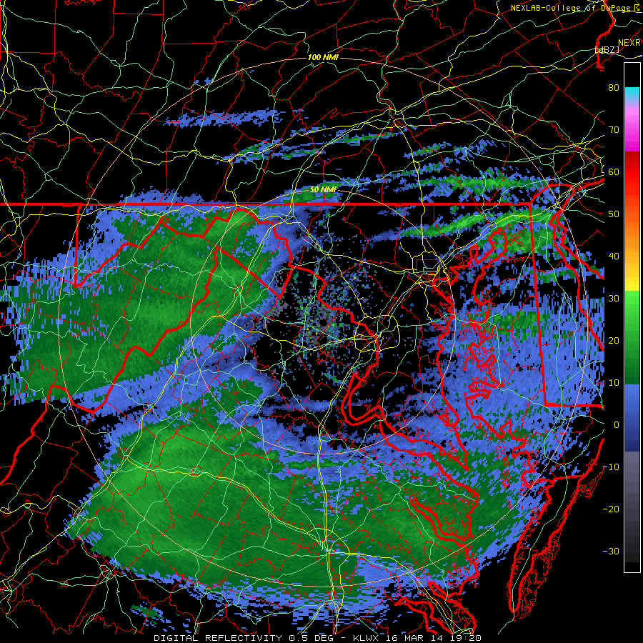
Radar is filling in as the air column becomes saturated. Precip in the form of snow or rain/snow turning to snow should start within the hour. The snow will be light and primarily non-accumulating for an hour or 2 before temps drop.
The SPC issued a mesoscale discussion highlighting the threat of heavy snow with rates around 1 inch per hour.

Light rain/snow showers have broken out across the area. This is a little earlier than expected but this should not significantly affect our snow totals. Temps are in the upper 30s to low 40s and dropping fast. The upper levels are cold and therefore conducive for snow. The simple fact that it is snowing with temps in the 40s attests to the shallowness of the warm layer. Recent model runs have held steady with the idea that the DC area is the jackpot. We have an increasing chance that this storm may exceed snowfall expectations. In the middle of March. The WPC has us in the high chance (>70%) of getting at least 4 inches of snow and a moderate chance (>40%) of getting 8 inches.
Go with the NWS forecast, not mine since I have no experience. I just put my guess of 3-5 inches out for the record.
The NWS forecast:
The NWS rationale to raising snow totals:
Temperatures have risen into the mid to upper 40s. However, dewpoints have dropped into the upper teens. Temps should halt their rise and begin to drop as clouds roll in from the west. This is the anxious waiting time. I'm going to say 3-5 inches for the area (up from 2-4 too much for those who saw that) . Do be aware that it could be lower if temps lag. The NWS has gone more aggressive, with 4-8 inches for the southern part of the county and 3-7 for the northern part.
ORIGINAL TEXT:
The National weather service has issued a Winter Storm Warning for Montgomery County and points south.
Radar is filling in as the air column becomes saturated. Precip in the form of snow or rain/snow turning to snow should start within the hour. The snow will be light and primarily non-accumulating for an hour or 2 before temps drop.
 |
| Radar does not update |
The SPC issued a mesoscale discussion highlighting the threat of heavy snow with rates around 1 inch per hour.
   MESOSCALE DISCUSSION 0195
   NWS STORM PREDICTION CENTER NORMAN OK
   0328 PM CDT SUN MAR 16 2014

   AREAS AFFECTED...PORTIONS OF CENTRAL/ERN WV INCLUDING THE
   PANHANDLE...CENTRAL/NRN VA...MUCH OF MD...DC

   CONCERNING...HEAVY SNOW

   VALID 162028Z - 170230Z

   SUMMARY...SNOW WILL DEVELOP THROUGH EARLY EVENING WITH RATES OF ONE
   INCH/HR DEVELOPING BY...AND ESPECIALLY BEYOND...02Z.

   DISCUSSION...A LARGE AREA OF PRECIPITATION CONTINUES TO LIFT NEWD IN
   ASSOCIATION WITH ISENTROPIC LIFT AHEAD OF A DE-AMPLIFYING UPPER LOW
   OVER THE MID-MS VALLEY. A DIFFUSE SFC LOW...CURRENTLY OVER NERN
   MS...WILL MOVE INTO THE SRN APPALACHIANS BY 02Z. RESULTING N/NE
   LOW-LEVEL FLOW WILL CONTINUE TO ADVECT VERY DRY AIR INTO THE
   DISCUSSION AREA...AND INITIALLY DRY LOWER LEVELS OF THE ATMOSPHERE
   WILL COOL/SATURATE WITH TIME ALLOWING FOR SNOW TO BECOME THE
   DOMINANT P-TYPE...BECOMING WIDESPREAD DURING THE EVENING HOURS.
   LATEST GUIDANCE CONTINUES TO DEPICT A STRENGTHENING BAROCLINIC ZONE
   ACROSS THE DISCUSSION AREA THIS EVENING WITHIN CONFLUENT 700 MB
   FLOW...WITH DEFORMATION-INDUCED FRONTOGENESIS EXPECTED TO DEVELOP
   WITHIN THE 800 MB TO 700 MB LAYER. MESOSCALE BANDING WILL LIKELY
   PRODUCE SNOWFALL RATES OF ONE INCH/HR BY...AND ESPECIALLY
   BEYOND...02Z.

   ..BUNTING.. 03/16/2014


   ATTN...WFO...PHI...AKQ...LWX...RNK...PBZ...RLX...

   LAT...LON   39128038 39517834 39517611 38917585 38287607 37887711
               37677889 37668001 37788053 38258095 39128038
4:45PM UPDATE:Light rain/snow showers have broken out across the area. This is a little earlier than expected but this should not significantly affect our snow totals. Temps are in the upper 30s to low 40s and dropping fast. The upper levels are cold and therefore conducive for snow. The simple fact that it is snowing with temps in the 40s attests to the shallowness of the warm layer. Recent model runs have held steady with the idea that the DC area is the jackpot. We have an increasing chance that this storm may exceed snowfall expectations. In the middle of March. The WPC has us in the high chance (>70%) of getting at least 4 inches of snow and a moderate chance (>40%) of getting 8 inches.
 |
| Chance of snow accumulation >8 inches |
Go with the NWS forecast, not mine since I have no experience. I just put my guess of 3-5 inches out for the record.
The NWS forecast:
The NWS rationale to raising snow totals:
ADJUSTMENTS FROM THE MORNING FORECAST INCLUDE...BUMPING UP
SNOWFALL TOTALS ACROSS THE NORTHERN CWA THINKING MOST AREAS WILL
BE SOUTH OF THE GRADIENT THAT SETS UP NEAR THE MASON-DIXON LINE.
ALSO...LATEST GUIDANCE CONTINUES TO SHOW THE POTENTIAL FOR
MESOSCALE BANDING ACROSS THESE AREAS LATE TONIGHT INTO MONDAY
MORNING...WHICH COULD CAUSE HIGHER SNOWFALL AMOUNTS. THE WARNING
HAS BEEN EXTENDED IN AREA TO INCLUDE ALL OF NORTHERN
VIRGINIA...PORTIONS OF THE EASTERN WEST VIRGINIA PANHANDLE AND THE
BALTIMORE METROPOLITAN AREA. THE WARNING MAY NEED TO BE EXPANDED
EVEN FARTHER NORTH TOWARD THE MASON-DIXON LINE DEPENDING ON
EXACTLY WHERE THE HEAVIER BANDS OF SNOW DEVELOP.
2:00PM UPDATE:
Temperatures have risen into the mid to upper 40s. However, dewpoints have dropped into the upper teens. Temps should halt their rise and begin to drop as clouds roll in from the west. This is the anxious waiting time. I'm going to say 3-5 inches for the area (up from 2-4 too much for those who saw that) . Do be aware that it could be lower if temps lag. The NWS has gone more aggressive, with 4-8 inches for the southern part of the county and 3-7 for the northern part.
ORIGINAL TEXT:
The National weather service has issued a Winter Storm Warning for Montgomery County and points south.
THE NATIONAL WEATHER SERVICE IN BALTIMORE MD/WASHINGTON HAS
ISSUED A WINTER STORM WARNING FOR SNOW...WHICH IS IN EFFECT FROM
7 PM THIS EVENING TO 2 PM EDT MONDAY. THE WINTER STORM WATCH IS NO
LONGER IN EFFECT.

* PRECIPITATION TYPE...SNOW

* ACCUMULATIONS...3 TO 6 INCHES.

* TIMING...A MIX OF RAIN AND SNOW EARLY THIS EVENING WILL CHANGE
  TO ALL SNOW BY MID EVENING. SNOW WILL CONTINUE OVERNIGHT THROUGH
  EARLY AFTERNOON MONDAY. THE HEAVIEST SNOW IS EXPECTED AFTER
  MIDNIGHT TONIGHT THROUGH EARLY MONDAY MORNING.

* TEMPERATURES...FALLING INTO THE LOWER 30S BY MID EVENING AND
  THEN DROPPING INTO THE MID TO UPPER 20S LATE TONIGHT. HIGHS
  MONDAY IN THE LOWER 30S.
As usual, temperatures will be an issue and if we don't drop as fast as modeled, we may just get non accumulating snow. That being said, Models have also bought into a more northerly solution with more precip. Need to go out. Updates late.
Subscribe to:
Posts (Atom)