Tuesday, December 17, 2013

ESS Test Notes...


Content of the atmosphere-air
  • Gases over 1 ppm in order excluding water vapor (dry air)

Nitrogen
Oxygen
Argon
Carbon Dioxide
Neon
Helium
Methane
Krypton


  • General trends of why these are the gases in the atmosphere
These gases are relatively stable (many are noble gases), and come from the ground in the form of outgassing, volcanic eruptions, ect. Oxygen is an exception,  it does not come from the ground but instead is produced through photosynthesis by plants. Nitrogen is stable because it has a triple bond...
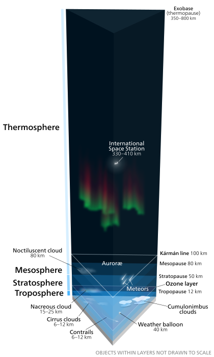
Divisions of the atmosphere by temperature
Troposphere-Where most weather occurs, temperatures decrease throughout this layer. It is warmest near the ground because the ground absorbs what radiation that makes it to the surface and conducts it to the air near it. It is about 12 km thick.
Stratosphere-Ozone layer is here. Temperature rises as altitude increases because Ozone layer absorbs UV radiation and gives off heat.
Mesosphere-Temperature drops, lowest temperatures typically found here.
Thermosphere- Temperature rises because the incoming solar radiation is not filtered out and any particles it encounters will be highly energized.
Earth's atmosphere Layers of the atmosphere drawn to scale, objects within the layers are not to scale.
  • Why does the temperature change at each level?
The temperature changes at each level because
Ozone
  • The basic chemistry behind how ozone is generated
O
2
 +  λ (photon energy) → 2 O
O + O
2
  → O
3
 
O
3
 + O → 2 O
2


  • What is needed and why does it happen in the stratosphere as opposed to higher up or lower in the atmosphere?
Higher up, there is not enough particles to make Ozone, and lower down, there is not enough solar radiation to break up the particles to make Ozone.


  • Is the Tropopause always at the same altitude everywhere on earth?  Why not?
The Tropopause is not at the same altitude everywhere on earth because the temperature of the surface varies. The colder the surface of the earth, the lower the Tropopause.


  • Why does the ozone hole exist?  Why is it located where it is?
The ozone hole is located over the Southern Ocean in the southern hemisphere. It is located here because the most chloride from the ocean make it up into the ozone layer here, destroying it. The ozone destruction is normally pretty balanced but with the introduction of human made CFCs into the atmosphere, the balance has been tipped in the way of destruction, resulting in the ozone hole.
O +Cl →ClO-
ClO-+O3  → 2O2+Cl
ClO-+O  → O2+Cl
Humidity
  • What is it?
Humidity is the amount of water vapor in the air.
How is it expressed?
  • Mixing ratio- expressed as grams of H2O/Kg dry air


  • Relative Humidity- expressed as Amt H2O actually in the air/max amt H2O possible. The number is expressed as a percentage. The amount of water actually in the air varies by temperature. The higher the temperatures the more water the air can hold so 100% humidity at 0 C will be less than 100% humidity at 30 C.
  • What factors affect relative humidity?
Temperature and the amount of water vapor available in the atmosphere affects humidity.
  • Dew Point 
The Dew Point is the temperature at which the air is saturated with water vapor and cannot absorb ant more. It varied depending on where you are. the dryer the air, the lower the dew point.
Trends as air rises through the atmosphere
  • Be familiar with dE = q - PdV (d is delta)


  • Why does the temperature go down?
As the air rises, the force of gravity decreases because there is less air pushing down on it so the parcel expands. As volume increases,  PdV increases, but since it is subtracted from the q, total energy change is negative, which indicates a drop in temperature


  • What is the adiabatic assumption?
the assumption is that the air parcel is a closed system and no heat goes in or out of it.


  • Why does the rate decrease at the cloud level?
Condensation of water vapor releases heat into the air parcel (system). q is no longer 0, it is positive.
Processes that lift air (forcing mechanisms) 
  • Frontal Wedging-Cold air mass displaces warm air mass upwards. The advancing edge of the cold air mass is like a wedge.
  • Orographic Lifting-Air is  forced over a land feature, such as mountains, cools, condenses and forms clouds. Wetter on the upslope side and dryer on the downslope side-rain shadow effect
  • Convergence-2 air masses travel towards each other (converge) and so where does the air go in the middle? the only place it can, up.
  • Localized Convective Heating-sun heats surface, air parcel above heats up, destabilizes, becomes less dense, and rises.

ELR vs DAR vs WAR

ELR is Environmental Lapse Rate This is the measured rate that the temperature of the atmospheric environment changes and varies from place to place between 5C/km and 10C/km.

DAR is Dry adiabatic Rate, the rate that rising unsaturated air cools, which is around 10C/km.

WAR is an organized and often prolonged conflict that is carried out by states or non-state actors. It is generally characterized by extreme violence, social disruption, and economic destruction....
Actually, it is the Wet adiabatic Rate, which is the rate rising saturated air cools. the rate is around 6C/km. the WAR is lower than the DAR because water condensing releases heat. So if the air parcel is saturated, it can no longer hold more moisture. But as it rises, the temp drops, allowing more water to condense, releasing more heat.

Unstable vs Stable air
Stable Air has a tendency to sink. The temperature of the air parcel is lower than the surroundings.

Unstable Air has a tendency to rise. The temperature of the air parcel is higher than the surroundings. rising unstable air forms convective clouds that form thunderstorms.

What do clouds need to form?
Water an condensation nuclei (particles for water to begin condensing onto; can be almost anything small enough)

Types of clouds (there are 11) by form and height
Precipitation formation, be familiar with both methods
Collision coalescence
Water vapor in the cloud collide with a nuclei, forming a water drop. This drop in turn collides with more water droplets, growing bigger and bigger until it falls out of the sky due to gravity as rain.

Bergeron Process-when cloud temps are below freezing
If you have any questions, please do not hesitate to ask using the comments. 
Hope this helps, 
-Alex


Monday, December 16, 2013

A dusting?

A clear night is expected early, follow by cloudiness and possibly up to a dusting of snow, as a clipper passes by. A clipper, AKA Alberta Clipper, is a low pressure system that originates out of Canada. they are usually moisture starved and carry very little snow by the time it gets here. Occasionally, the clipper transfers its energy offshore and bombs out, creating a snowstorm. One example is the second snowstorm of February 2010. As stated previously, these storms do not happen very often. 2 clippers are expected to pass in the next 2 days. One tomorrow morning and one tomorrow afternoon. The second one will be a little bit stronger but temps should be warm enough to limit any accumulations. After the clippers, a warming trend is expected with temps into the mid to upper 50's by the end of the week.