Tuesday, January 28, 2014

Winter Storm Wreaks Havoc in the South

Today was a standard 2014 cold, dry, sunny day. DCA recorded a high of 23 at 12:00 AM, with temperatures dropping throughout the day due to continued cold air advection from behind the cold front.While we sit here and shiver, alaska is comparably balmy, even bordering on hot! Anchorage, Alaska recorded a high of 50 degrees today with light rain. While the polar air dominates our weather, record warmth has gripped the west and Alaska.
 Tonight, as temperatures fall back into the lower teens, a winter storm, currently pounding the deep South with a mixed bag of frozen precip, approaches the area and may swipe us with a dusting to an inch of snow. anything more than an inch is very unlikely although computer models have been trending a tad north every run. Areas to the south and east have a higher chance of receiving any precip, with up to 2-3 inches of snow possible. Those to the north and west can expect cloudy skies and maybe a flurry or snow shower tonight amounting, at most, to a dusting. Tomorrow will be partly cloudy as the storm pulls out, with highs in the low 20s.

 Computer models:

The NAM gives us more precip, with 1-4 inches across the area both in the 12z and 18z runs. Notice the tight snow gradient


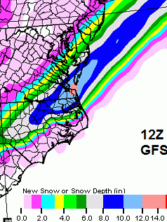
The 12z and 18z GFS gives us barely a dusting with the bulk of the snow to our south. Notice the very tight snow gradient characteristic of many snowstorms this year. As with the other storms,  a track shift of 25 miles could result in a difference of a couple of inches either way.

This storm has already thrown some curveballs across the deep South. Traffic in Atlanta was thrown into a mess when 1-2 inches of unforecasted snow started falling around noon. Traffic mayhem ensued when unprepared motorists got caught in accidents in the snow. As stated before, the deep south has almost no capability to respond to winter weather due to the rarity of these events. Below are some images of the gridlock.

Progression of traffic while the snow falls. Green is good traffic and dark red is gridlock.
Due to warm air aloft across the gulf coast, snow melts while falling and depending on how thick the surface layer of cold air is, the  rain may refreeze to sleet or remain liquid and freezes on contact with objects below freezing in the form of freezing rain. Freezing rain is the most disruptive form of winter precipitation because it can weigh down trees and powerlines. Western portions of south-central Alabama are under a civil emergency due to hazardous roads which limits travel to only emergency vehicles. In addition, practically nothing can drive on ice and it cannot be plowed like snow. The closer to the coat, the more freezing rain there is, and the less sleet and snow there is. as a result, a major ice storm is expected on the SC coast with forecast ice accretion in excess of .5 inches, possible leading to power outages up to a week long.

Icicles in Mobile, Alabama where freezing rain and sleet fell
Light snow is definitely possible off of this storm as it grazes us from the south. However, chances are not very high for anything greater than an inch. Beyond this, a warm up to near 50 and rain is forecast for the end of the week through the weekend before possibly cooling down again after.

Hope for snow and thanks for reading!
-Alex

Monday, January 27, 2014

Hope is not lost... a tiny bit remains...

Due to the recent shifts north by model runs, the Sterling NWS has had some changes about the incoming storm. They think it should stay well to our south  but have reservations about that and mention the possibility of it creeping farther north than currently advertised. Do they know something that we don't? I personally think that the precip shield will not make it to the DC metro... we shall see...

This is what they say...
.SHORT TERM /TUESDAY NIGHT THROUGH WEDNESDAY NIGHT/...
LOW PRESSURE OFF THE SOUTHEAST COAST TUESDAY NIGHT WILL MOVE
NORTHEAST AWAY FROM THE COAST LATE TUESDAY NIGHT AND WEDNESDAY.
GUIDANCE HAS KEPT THE PRECIPITATION OFF TO OUR SOUTH AND EAST
RECENTLY. HOWEVER...THE LATEST TREND IN THE DETERMINISTIC MODEL
RUNS BRING SOME PRECIPITATION FROM THE LOW FARTHER NORTH AND WEST
INTO OUR CWA. THERE IS ALSO UNCERTAINTY IN THE ENSEMBLE FIELDS
WHICH INDICATE A POSSIBILITY OF SNOW REACHING WELL INTO OUR CWA.

OUR LATEST SNOW PROBABILITY MAPS WHICH TAKE INTO ACCOUNT THE
ENSEMBLE FIELDS SHOW THE HIGH DEGREE OF UNCERTAINTY. UPDATED THE
LATEST FORECAST TO INCLUDE POSSIBLE SNOW FOR LOCATIONS NEAR AND
EAST OF I-95. AS OF NOW...IT LOOKS LIKE THE BEST CHANCE FOR
ACCUMULATING SNOW WILL BE ACROSS SOUTHERN MARYLAND...BUT AGAIN
UNCERTAINTY IS HIGH AND THIS NEEDS TO BE MONITORED.

Ice+this...

This is not going to be fun to drive on...

Bridge City TX

Forecast
  • TuesdayFreezing rain. Temperature falling to around 27 by 5pm. North wind 15 to 20 mph. Chance of precipitation is 80%. New ice accumulation of 0.1 to 0.3 of an inch possible.

Major Storm to hit the south...


While we had a short reprieve from the cold temperatures today, an arctic front has passed by, causing temperatures to plummet. Lows by tomorrow morning will be around 5 degrees and highs tomorrow will only be in the teens. The cold front will advance towards the gulf coast, interacting with subtropical energy. This will result in a massive winter storm for the south while we freeze, with the snow shield just to the south. The storm will exit the area on wednesday.

New Orleans winter wx forecast
Winter storm and ice storm warnings are in effect for most of the gulf coast and carolina coasts. Areas along the gulf coast will mainly deal with a nasty mix of freezing rain and sleet transitioning to snow with between .25 and .5 inches of ice expected. The farther south, the less snow and he more ice there is because although the cold air will make it far south, it will bu overrun by warm air, which will mean that any precip that falls will be liquid. Farther north, the cold air is deeper so the precip has time to refreeze into sleet or remain as snow all the way down.

In the eastern Carolinas with the exceptions of areas close to the shore and farther south, the precipitation will mostly be in the form of snow. Coastal south carolina is under a ice storm warning for .25-.75 inches of ice accretion, meaning that there will be a shell of ice on trees, power lines, roads, and everything else. This is dangerous even to New Englanders that are used to the snow. This amount of ice will break trees and weigh down power lines, not to mention that the infrastructure to deal with winter weather is non-existent across the deep south.

Farther north, .25-.5 inches of ice will give way to sleet and snow and areas to the north and west will receive mainly snow, with up to a foot expected. Areas far to the north and west from Western NC through Southern MD can expect less snow. As with all the storms this season, there will be a extremely tight gradient in the precipitation shield so a small shift of a few tens of miles can result in the a difference between a foot and only a couple of inches.
Watches, Warnings and Advisories 

Forecast snow totals:


3 day 50 percentile snow accumulation- snowfall has a 50/50 chance of being either greater or less than this.

This is the most likely scenario, with 1-3 inches across GA and SC, 4-6 across central NC and northern SC, and a swath of 6-8 inches across eastern NC through the Virginia beach area. The snow totals are likely overdone toward the west due to the extremely tight precip gradient with this storm.

These are the 90 percentile snow accumulations, meaning that there is a 90% chance of the snowfall being less than this.
This is what can be considered the reasonable "worst case scenario" for any given area. Not all the area will reach this threshold but some small areas where the most intense snow bands up may reach this. It forecasts 1-3 across central Mississippi and Alabama. GA is increased to 4-6 around the center and 1-3 to the north and south. The 6" contour extends from GA to the Delmarva peninsula. central and eastern NC is hammered with 8-15 inches of snow although the coasts get considerably less due to warm air intrusion in the mid to lower levels off the ocean.

This is a very serious event for the south as they are not accustomed to this weather. Even by northern standards, an half an inch of ice accretion and a foot of snow is a major event. They have no way of dealing with this in the south. In addition, temperatures will remain in the low 40s with lows in the 20s, which will promote slow melting, keeping the region encased in ice or buried by snow for a long time.

Sunday, January 26, 2014

Uncertainty...

This basically shows how complicated forecasting is...

AREA FORECAST DISCUSSION
NATIONAL WEATHER SERVICE BIRMINGHAM AL
332 PM CST SUN JAN 26 2014

.DISCUSSION...

YOU WOULD THINK THAT AS A POTENTIAL EVENT APPROACHES...FORECAST
CONFIDENCE WOULD EVENTUALLY INCREASE. BUT WITH A FICKLE
OVERRUNNING EVENT INTERACTING WITH AN ARCTIC FRONT...IT SEEMS THAT
THE BUTTERFLY EFFECT IS IN FULL FORCE. WE ARE NOW WITHIN 48 HOURS
OF A POSSIBLE WINTER STORM...AND THE MODELS CONTINUE TO RANGE FROM
SIGNIFICANT AND WIDESPREAD...TO VIRTUALLY DRY.

THE NAM HAS ESSENTIALLY STUCK TO ITS GUNS IN BEING THE WETTEST
MODEL WITH THIS SYSTEM. THE ONCE-DRY GFS IS NOW JUST AS WET AS THE
NAM...WHILE THE ONCE-WET CANADIAN IS MORE ON BOARD WITH THE
ALWAYS-DRY EUROPEAN. WOW. THE PATTERN IS SO COLD AND SO DYNAMIC
THAT I THINK NOW IS THE TIME THAT WE ACQUIESCE TO THE POTENTIAL
FOR A WINTER STORM IN AT LEAST THE SOUTHERN PORTION OF OUR
FORECAST AREA.

Anything could change at anytime...

Deep South Winter Storm

While we sit in the frigid cold and watch what's left of the snow sublimate away into the dry air, us weather nerds have been looking ahead to the next storm. In the Mid Atlantic, there does not seem to be any credible potential for snow within the next week although it will be quite cold. A "warm up" to the mid 30's is possible tomorrow morning before plummeting for the rest of the week. temperatures cold rise again next weekend. Since we will be in the heart of the cold high pressure, there will be no precip. The low pressure systems travel around the high. As a result storms will be shunted south around the high, setting up the south for frozen precip.

The setup seems good for a storm. Southern energy from the Pacific crosses over into the gulf while energy dives down from the north, and a surface low forms in the gulf. With the bitterly cold air in place, precipitation has a large chance of being frozen. The proximity to the warm gulf provides for plenty of moisture and as a result plenty of precip, much of it frozen, falls and accumulates.

Although they vary significantly with details, the models have been remarkably consistent with bringing some form of heavy frozen precip (snow, sleet, freezing rain) to from the gulf coast to Virginia beach with a the heaviest swath over the coastal Carolinas. There, snow accumulations over 6 inches are possible. Farther south, 1-2 inches of snow is possible with ice accumulations as the cold air undercuts the warm air. Areas directly on the coast will have the least frozen precip because of the moderating effect of the ocean. Ice accumulations of .25 inches is possible. The heavy wet snow and ice will weigh down the power lines and trees while the cold temperatures and poorly insulated houses will create a extremely high demand for electricity, stressing the electrical grid. The frozen precip will cause major traffic issues and could shut down the south.

Here are the 3 main models we use to make forecasts. Be aware these snowfall maps are using 10:1 ratios and the ratios will be likely much lower, around 6:1. In addition, the cold air closer to the coast will be quite shallow leading to sleet and freezing rain, cutting down on snow totals and being models, the scenarios being portrayed by the models will not be what will actually happen.

12z NAM


12z GFS


12z ECMWF
Being in a subtropical climate, the areas expected to be impacted by this storm is not prepared for any winter precip, let alone a full blown winter storm. As a result, the criteria for a winter storm warning is lower than it is farther north. Here are the NWS offices's takes on the upcoming storm.

 NWS Houston
...WINTER STORM WATCH FOR TUESDAY...

.AN ARCTIC AIRMASS WILL SETTLE OVER THE AREA LATE MONDAY DROPPING
TEMPERATURES TO AROUND FREEZING TO WELL BELOW FREEZING TUESDAY
MORNING. AN UPPER LEVEL DISTURBANCE WILL MOVE TOWARD THE REGION
FROM THE SOUTHWEST HELPING TO INITIATE THE DEVELOPMENT OF
SNOW...FREEZING RAIN...AND SLEET. THIS WINTER PRECIPITATION SHOULD
CONTINUE THROUGHOUT THE DAY AND TAPER OFF FROM NORTHWEST TO
SOUTHEAST BY EVENING ALONG THE COAST. SIGNIFICANT ICING IS LIKELY
ACROSS THE REGION. SNOW FALL ACCUMULATIONS OF 1 TO 2 INCHES SHOULD
BE COMMON OVER THE NORTHERN HALF OF SOUTHEAST TEXAS WITH ISOLATED
HEAVIER AMOUNTS. TEMPERATURES SHOULD BOTTOM OUT WEDNESDAY MORNING
IN THE 20-25 DEGREE RANGE FROM INTERSTATE 10 NORTHWARD.

NWS New Orleans

THE NATIONAL WEATHER SERVICE IN NEW ORLEANS HAS ISSUED A WINTER
STORM WATCH...WHICH IS IN EFFECT FROM TUESDAY MORNING THROUGH
LATE TUESDAY NIGHT.

* TIMING...A WINTRY MIX OF PRECIPITATION COULD BEGIN AS EARLY AS
  TUESDAY MORNING...WITH THE HEAVIEST PRECIPITATION EXPECTED
  TUESDAY AFTERNOON AND EVENING.

* IMPACTS...SNOW AMOUNTS IN EXCESS OF TWO INCHES AND SLEET AND
  FREEZING RAIN ACCUMULATIONS OF A QUARTER INCH OR MORE ARE
  POSSIBLE ACROSS THE ENTIRE AREA. TRAVEL CONDITIONS ARE EXPECTED
  TO BECOME DIFFICULT DUE TO ICY ROADS AND BRIDGES DURING THE DAY
  ON TUESDAY. IN AREAS WHERE SIGNIFICANT FREEZING RAIN
  OCCURS...SPORADIC POWER OUTAGES ARE POSSIBLE. THE HIGHEST
  POTENTIAL FOR FREEZING RAIN WILL BE ACROSS SOUTHEAST LOUISIANA
  SOUTH OF LAKE PONTCHARTRAIN INCLUDING THE CITY OF NEW ORLEANS.

NWS Wilmington 
 
...WINTER STORM WATCH IN EFFECT FROM TUESDAY AFTERNOON THROUGH
WEDNESDAY AFTERNOON...

THE NATIONAL WEATHER SERVICE IN WILMINGTON HAS ISSUED A WINTER
STORM WATCH...WHICH IS IN EFFECT FROM TUESDAY AFTERNOON THROUGH
WEDNESDAY AFTERNOON.

* LOCATIONS...SOUTHEAST NORTH CAROLINA AND NORTHEAST SOUTH
  CAROLINA.

* HAZARD TYPES...SNOW AND SLEET. POCKETS OF FREEZING RAIN ARE
  POSSIBLE.

* ACCUMULATIONS...THE RISK FOR SIGNIFICANT ACCUMULATIONS OF SNOW
  AND SLEET IS INCREASING. SNOW AMOUNTS MAY EXCEED 3 INCHES.