Saturday, February 25, 2017

Back to our regular scheduled programming... Or is it now?

Well the cold front put a pause on our inevitable march towards spring. Over the course of the day we've gone from record warmth to slightly above normal temperatures. Today's high was in the low 60s and lows will probably dip to the mid 20s. Average high/low temperatures for 2/25 is 36/18 F.

In Ithaca, some days are like this...
Ideal morning walking conditions...
But some days we get this:
Early blooming Ranunculaceae at the Cornell Botanic Gardens...


Though I must say it is a bit early... Winter normally would have a firm grip well into March. Maybe we can score some seasonal weather after the next warm snap next week. Can 't really complain about this weather though...
Robin on the Ag Quad


The end is near!!!! of the warmth...

Another day, another record teetering on the edge. Warm southerly flow ahead of a cold front will push temperatures well into the 60s. The point and click forecast for Cornell from the NWS shows a high temeprature of 63 for today. The record for today was 63 degrees set in 1985. However, raw short term model outputs suggest potential for temperatures to exceed that of forecast, as it has all week. Thus, another temperature record may fall today in this unprecedented warm snap.
12z HRRR temperature forecast.
As with all things, the beautiful weather will end. A cold front will approach this afternoon, binging potentially severe thunderstorms. Wind gusts in excess of 40 mph is possible (the threshold for severe is 58mph) and temperatures will plunge into the 40s with the frontal passage. Heavy rain is expected. The front is expected to arrive around 1PM and will take a couple of hours to pass. To complete the day of weather craziness, snow showers will be possible tonight after to frontal passage.
NAM 3K simulated radar showing storms just west of Ithaca.

NAM 3k Simulated Radar for 3PM shows storms rapidly strengthening just east of Ithaca.

Wednesday, February 22, 2017

Feburary Break is the new Spring Break

Winter may begin on December 1st of the 21st but one thing that meteorologists and the general public agrees is that February is still winter. That being said, February is the end of winter. That being said, I've heard that March is still winter in Ithaca. Well, after a long 3 weeks of second semester, I went back to the tropics of Maryland. Took a trip down to National Arboretum in DC to see spring come a month early. Every day over Break in DC was in the 70s. It was glorious.


The Japanese Apricots (Prunus mume) were in full bloom. They are the earliest blooming of the Prunus genus (cherry, peach, apricot, ect) There are probably hundreds of varieties out there, red pink, white, double, single, you name it. It's such a cute tree but not planted very often.
 The earlier camellias are actually done blooming. They've been lucky not to be wrecked by frosts (as if there have been any).


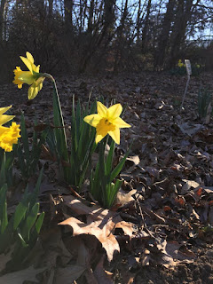
Elsewhere, the traditional spring flowers, Cornelian cherry (Cornus mas), top; Snowdrops on the left, and Daffodils on the right. In other garden news, the famous cherry blossom buds are starting. The peony buds are ready to pop. All they're waiting for is some persistent warmth. The forecast doesn't seem to want to drop temperatures below freezing for a while so the growing season is probably going to start for many plants, especailly those imported from areas less prone to large temperature swings (Asian Magnolias I'm looking at you). If that pans out, let's hope there are no late cold snaps. Otherwise we're going to get some unhappy gardens.