For the record, we got a day off. It was 36.7 @7:30AM. Temps spiked up to 45 by 8:15AM. Never underestimate the power of cold ground. Ice didn't melt until the plow came by and salted the road in the pouring rain at 9AM.
12:45PM Tuesday 2/16/2016 Update:
Playing catchup are we...
MDZ503>506-161300-
/O.UPG.KLWX.WW.Y.0008.000000T0000Z-160216T1500Z/
/O.EXA.KLWX.WS.W.0003.000000T0000Z-160216T1500Z/
NORTHWEST MONTGOMERY-CENTRAL AND SOUTHEAST MONTGOMERY-
NORTHWEST HOWARD-CENTRAL AND SOUTHEAST HOWARD-
1158 PM EST MON FEB 15 2016

...WINTER STORM WARNING IN EFFECT UNTIL 10 AM EST TUESDAY...

THE NATIONAL WEATHER SERVICE IN BALTIMORE MD/WASHINGTON HAS
ISSUED A WINTER STORM WARNING FOR FREEZING RAIN...WHICH IS IN
EFFECT UNTIL 10 AM EST TUESDAY. THE WINTER WEATHER ADVISORY IS NO
LONGER IN EFFECT.

* PRECIPITATION TYPE...FREEZING RAIN.

* ACCUMULATION...AROUND A QUARTER INCH OF ICE FROM FREEZING RAIN.

* TIMING...PRECIPITATION WILL GRADUALLY CHANGE TO RAIN TUESDAY
  MORNING.

* WINDS...SOUTHEAST 5 TO 10 MPH

* TEMPERATURES...IN THE UPPER 20S...RISING TO AROUND 40 BY
  TUESDAY MORNING.

* IMPACTS...ICE WILL CAUSE SLIPPERY ROADS AND TRAVEL WILL BE
  DIFFICULT.

PRECAUTIONARY/PREPAREDNESS ACTIONS...


A WINTER STORM WARNING MEANS SIGNIFICANT AMOUNTS OF SNOW...
SLEET...AND ICE ARE EXPECTED OR OCCURRING. STRONG WINDS ARE ALSO
POSSIBLE. THIS WILL MAKE TRAVEL VERY HAZARDOUS OR IMPOSSIBLE.


&&

$$
9:40PM Monday 2/15/2016 Update:
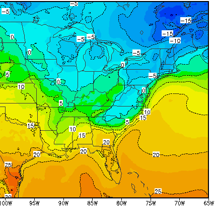
Cold air is holding its own at the surface. We have a bootleg CAD scenario that is keeping the winds out of the north. However, with every wave of rain, we should find that our temps rise. This is because the rain releases heat when it freezes. Also, temperatures aloft are well above freezing.
 |
| Max temperature anywhere in the atmosphere (in this case, the mid to upper levels) |
 |
| Temperatures 2m of the ground (Surface temperature) |
That's probably overdone with winds going over fresh snowpack but temperatures should be in the low 40s by the time MCPS needs to make its decisions so maybe a delay but we're probably going to school. In the meantime, we're iced over with temps ranging from 25-30 degrees across the region.
2:00PM Monday 2/15/2016 Update:
The flip is imminent. Probably in the next hour or so.
 MESOSCALE DISCUSSION 0102
NWS STORM PREDICTION CENTER NORMAN OK
1246 PM CST MON FEB 15 2016
AREAS AFFECTED...PORTIONS OF THE MID-ATLANTIC
CONCERNING...WINTER MIXED PRECIPITATION
VALID 151846Z - 152345Z
SUMMARY...WINTER MIXED PRECIPITATION WILL CONTINUE TO ADVANCE
NORTHWARD ACROSS THE MID-ATLANTIC REGION. A TRANSITION FROM SNOW TO
A PERIOD OF SLEET TO THEN FREEZING RAIN WILL OCCUR THROUGH THIS
AFTERNOON AND INTO THIS EVENING. FREEZING RAIN RATES UP TO SEVERAL
HUNDREDTHS OF AN INCH PER HOUR WILL BE POSSIBLE.
DISCUSSION...AS A MID-LEVEL IMPULSE ROUNDS THE BASE OF A BROAD
EASTERN U.S. TROUGH...A TIGHTENING HEIGHT GRADIENT ALOFT WILL
ENCOURAGE STRENGTHENING SWLY FLOW AND CONTINUED/INCREASING
ISENTROPIC ASCENT ACROSS MUCH OF THE MID-ATLANTIC REGION. AS A
RESULT...PRECIPITATION SHOULD CONTINUE TO EXPAND NORTHWARD TOWARDS
SOUTHERN NEW ENGLAND. IN CONJUNCTION WITH INCREASING WARM-AIR
ADVECTION ALOFT...A MELTING LAYER WILL CONTINUE TO PROGRESS QUICKLY
NORTH...RESULTING IN A CHANGE TO A BRIEF PERIOD OF SLEET...FOLLOWED
BY FREEZING RAIN THIS AFTERNOON INTO THIS EVENING. KDOX CC DATA
CURRENTLY DEPICT THE NORTHERN EXTENT OF THIS MELTING LAYER
STRETCHING FROM SOUTHERN DELAWARE W/NWWD TO NEAR DC. BASED ON KFCX
DATA...THIS TRANSITION ZONE THEN BENDS TO THE SOUTHWEST TOWARDS
LEWISBURG WV. EASTERN PORTIONS OF THIS TRANSITION ZONE WILL ADVANCE
MORE RAPIDLY N/NW OVER THE NEXT FEW HOURS...WITH FREEZING RAIN
LIKELY OVERSPREADING THE I-95 CORRIDOR FROM DC TO NYC OVER THE NEXT
FEW HOURS. INTO THIS EVENING...SNOW ACROSS SOUTHEASTERN PA WILL ALSO
TRANSITION TO MIXED PRECIPITATION AS THE MELTING LAYER PUSHES
FARTHER N/NW. FREEZING RAIN RATES UPWARDS OF SEVERAL HUNDREDTHS OF
AN INCH PER HOUR WILL BE POSSIBLE. CLOSER TO THE COAST...SFC
WARM-AIR ADVECTION WILL GRADUALLY RAISE TEMPS ABOVE
FREEZING...RESULTING IN A TRANSITION TO RAIN.
10:15AM Monday 2/15/2016 Update:
Snow/Sleet/Freezing Rain line is advancing towards Richmond. around 2 inches of snow has falled across MoCo; more snow to the south. 3PM flip to freezing rain expected here. Roads are already snow covered to it'll get messy real quick when the freezing rain comes.

MESOSCALE DISCUSSION 0100
NWS STORM PREDICTION CENTER NORMAN OK
0852 AM CST MON FEB 15 2016
AREAS AFFECTED...PORTIONS OF VA AND SRN MD
CONCERNING...WINTER MIXED PRECIPITATION
VALID 151452Z - 151845Z
SUMMARY...A MIXTURE OF SNOW...SLEET...AND FREEZING RAIN WILL
CONTINUE ACROSS PORTIONS OF VA AND SOUTHERN MD INTO THE AFTERNOON
HOURS. THE TRANSITION TO FREEZING RAIN WILL CONTINUE TO LIFT NORTH
QUICKLY...WHILE SNOW WILL REMAIN MORE COMMON ACROSS THE HIGHER
ELEVATIONS OF FAR WESTERN VA. FREEZING RAIN RATES OF SEVERAL
HUNDREDTHS OF AN INCH PER HOUR WILL LIKELY CONTINUE.
DISCUSSION...POLARIMETRIC RADAR IMAGERY DEPICTS A MELTING LAYER
AROUND 5000 FT AGL RAPIDLY ADVANCING NORTHWARD ACROSS MUCH OF
EASTERN/CENTRAL VA. FARTHER WEST...THIS LINE IS ONLY MAKING SLOWER
ADVANCES N/NW...WITH HIGHER ELEVATIONS ALONG THE VA/WV BORDER
REMAINING AS SNOW. THIS EXPANSIVE AREA OF PCPN IS BEING AIDED BY WAA
CENTERED AROUND 850 MB...AS RECENT AKQ VWP DATA CONFIRM STRONG
VEERING WITH HEIGHT IN THE LOWEST 2 KM. HI-RES GUIDANCE SUGGESTS
THIS MIXED PCPN WILL CONTINUE TO ADVANCE NORTHWARD...LIKELY
CHARACTERIZED BY A QUICK TRANSITION TO SLEET AND THEN FREEZING RAIN
AS THE WARM NOSE ALOFT DEEPENS OVERHEAD. INDEED...CC/ZDR DATA
DISPLAY A DOWNWARD-DESCENDING MELTING LAYER ON THE NORTH EDGE OF THE
WARM NOSE /KFVX E-NEWD TO KMFV AS OF 1430Z/...SUGGESTIVE OF A NARROW
ZONE OF ICE-PELLET POTENTIAL. THEREAFTER...A TRANSITION TO FREEZING
RAIN IS ANTICIPATED...WITH FREEZING RAIN RATES OF A FEW HUNDREDTHS
OF AN INCH PER HOUR POSSIBLE.
..PICCA.. 02/15/2016
11:00PM Sunday 2/14/2016
Snow just started. 21 degrees, dewpoint of 6 degrees. Let's get this started.
10:30PM Sunday 2/14/2016
Snow is moving into the area per radar. It should start in the within the next hour. 1-2 inches of snow is expected by sunrise. Then we lull before more snow arrives late morning. Current thinking is that precip begins to change over to freezing rain around 4PM although that can change. After the transition, precip becomes spotty, with light freezing rain and drizzle until temperatures rise above freezing around 1AM as the slug of heavy rain approaches from the south.

Total snow expected: 3-5"
Total sleet: <0.5"
Total freezing rain accretion: <0.25"
The National Weather Service has issued a winter weather advisory:
...WINTER WEATHER ADVISORY REMAINS IN EFFECT FROM 1 AM MONDAY TO
10 AM EST TUESDAY...

* PRECIPITATION TYPE...SNOW...SLEET AND FREEZING RAIN.

* ACCUMULATION...2 TO 5 INCHES OF SNOW AND SLEET. AROUND ONE-
  TENTH OF AN INCH OF ICE FROM FREEZING RAIN.

* TIMING...SNOW WILL BEGIN BETWEEN MIDNIGHT AND 3 AM MONDAY
  MORNING. SNOW WILL CHANGE TO SLEET AND FREEZING RAIN MONDAY
  AFTERNOON...AND ALL FREEZING RAIN MONDAY EVENING. PRECIPITATION
  WILL GRADUALLY CHANGE TO RAIN LATE MONDAY NIGHT INTO TUESDAY
  MORNING.

* WINDS...SOUTHEAST 10 TO 15 MPH WITH GUSTS UP TO 20 MPH.

* TEMPERATURES...IN THE TEENS TO NEAR 20 TONIGHT...RISING INTO
  THE UPPER 20S TO LOWER 30S MONDAY INTO MONDAY NIGHT.
  TEMPERATURES WILL RISE INTO THE MID AND UPPER 40S TUESDAY.

* IMPACTS...SNOW AND ICE WILL CAUSE SLIPPERY ROADS AND TRAVEL
  WILL BE DIFFICULT.
Expect heavy rain and school on Tuesday unless the cold air magically holds.
10:00PM Saturday 2/13/2016 Update-About the Mon/Tues storm:
Well... The snow last night was a non-event, a complete no show for my house. But this morning a snow squall made up for that, dropping up to an inch of snow across Montgomery County, my 3rd largest snow event all year. Tonight, the coldest air of the year will build into the region, dropping temperatures to near 0. Temperatures should struggle to reach the low 20s tomorrow and dip back into the teens tomorrow night. On Monday, a storm will approach from the SW. Precipitation will start out as snow Monday morning and gradually switch over to a mix and then rain as the cold air retreats. This is a very complicated setup, arguable more so than last weeks (we all know how that went). So let's get to it.
First off, the National Weather Service has issued a Winter Storm Watch for snow and ice turning to rain Tuesday morning. This is probably the upper limit of what we can get barring a major shift.
...WIND CHILL ADVISORY REMAINS IN EFFECT UNTIL 9 AM EST SUNDAY...
...WINTER STORM WATCH REMAINS IN EFFECT FROM LATE SUNDAY NIGHT
THROUGH TUESDAY MORNING...

* WINDS...NORTHWEST 5 TO 15 MPH WITH GUSTS UP TO 30 MPH THROUGH
  TONIGHT. WINDS SUNDAY NIGHT THROUGH TUESDAY MORNING SOUTHEAST
  AROUND 5 TO 10 MPH.

* TEMPERATURES...FALLING INTO THE SINGLE DIGITS TONIGHT INTO
  SUNDAY MORNING...IN THE TEENS SUNDAY NIGHT RISING INTO THE UPPER
  20S TO LOWER 30S MONDAY INTO TUESDAY.

* WIND CHILLS...10 TO 20 DEGREES BELOW ZERO TONIGHT INTO SUNDAY
  MORNING.

* PRECIPITATION TYPE...SNOW...SLEET AND FREEZING RAIN SUNDAY NIGHT
  INTO TUESDAY MORNING.

* ACCUMULATION...POTENTIAL FOR AROUND 5 INCHES OF SNOW AND
  SLEET. POTENTIAL FOR AROUND A QUARTER INCH OF ICE FROM
  FREEZING RAIN.

* TIMING...LOWEST WIND CHILLS ARE EXPECTED LATE TONIGHT THROUGH
  EARLY SUNDAY MORNING. SNOW WILL BEGIN LATE SUNDAY NIGHT. SNOW
  WILL CONTINUE THROUGH MONDAY BEFORE CHANGING TO SLEET AND
  FREEZING RAIN MONDAY NIGHT. PRECIPITATION WILL END TUESDAY
  AFTERNOON.

* IMPACTS...THE DANGEROUSLY LOW WIND CHILLS WILL LEAD TO FROST
  BITE AND HYPOTHERMIA IF PRECAUTIONS ARE NOT TAKEN. SNOW AND
  ICE WILL CAUSE SLIPPERY ROADS AND TRAVEL WILL BE DIFFICULT.
After days of disagreement, all the global models have agreed on a low track that goes overhead. They have also agreed on a weaker, ill defined low pressure with a disorganized precipitation field. What they haven't agreed on is what happens to the cold air. Now throw in the shorter term mesoscale models and a situation fairly unique to our area and we got a royal mess to forecast.
Before the main low pressure, warm air aloft will overrun the cold air dome over us this is called warm air advection (WAA, literally meaning the advancement of warm air). This will produce light snow throughout Monday. Right now, around 2-4 inches of snow is expected on the front end. The moisture is more aimed towards our south than us so we are on the fringes. As the WAA turns N, the cold layer becomes shallower and shallower, eventually becoming so shallow that the snow turns to sleet and freezing rain. The changeover is expected around late afternoon, say 2:00-4:00PM. This is pretty well agreed on. The global models like the GFS and the EURO have the lowest amount of snow and quickest switchover. The higher resolution North American Mesoscale model (NAM) slows the switchover and is generally colder. This is probably because it shows light SE winds as opposed to S winds that the GFS shows.
Once we lose the upper levels, we lose it pretty quickly, so snow-to sleet-to freezing rain goes in a couple of hours. By 7 we should be freezing rain with temperatures in the upper 20s and low 30s. The NWS suggests that ice accretion could be up to a quarter inch. Surface temperatures go above freezing by 4AM Tuesday but temperatures stay in the low to mid 30s. A cold cold rain will fall. Since the ground is so cold, roads could remain icy well into the day Tuesday. That being said, we should be pouring rain for a while so that would overwhelm the cold ground, which leads to another concern. 1+ inches of water on a hard frozen ground will create excessive surface runoff. The globals torch us into the 40s and 50s by noon Tuesday and precip ends in early afternoon. However, the NAM keeps us in the 30s and low 40s
In any case, we could be in for a extended period of wintery precipitation as the cold air puts up a fight. It's a very touchy situation. Arctic airmasses are notoriously hard to move, but there is no support to back the air up the pool of cold air just sits and rots over us as warm air assaults it. One thing we know is that once you go above freezing, it's over. Prepare for the melt. Areas north and west will do better than the immediate metro. In any case, keep watching the storm but don't expect much out of it other than a warmup.
11:53AM Friday 2/12/2016 Update:
An advisory has been issued for the up to 1 inch of snow we will be getting tonight since it will fall during rush hour. The latest short term model guidance suggests that there may be isolated area with up to 2 inches of high ratio powder. Should be pretty before our washout on Tuesday.
DISTRICT OF COLUMBIA-FREDERICK MD-CARROLL-NORTHERN BALTIMORE-
SOUTHERN BALTIMORE-PRINCE GEORGES-ANNE ARUNDEL-CHARLES-
NORTHWEST MONTGOMERY-CENTRAL AND SOUTHEAST MONTGOMERY-
NORTHWEST HOWARD-CENTRAL AND SOUTHEAST HOWARD-NORTHWEST HARFORD-
SOUTHEAST HARFORD-PRINCE WILLIAM/MANASSAS/MANASSAS PARK-FAIRFAX-
ARLINGTON/FALLS CHURCH/ALEXANDRIA-STAFFORD-SPOTSYLVANIA-
NORTHERN FAUQUIER-SOUTHERN FAUQUIER-WESTERN LOUDOUN-
EASTERN LOUDOUN-
1137 AM EST FRI FEB 12 2016

...WINTER WEATHER ADVISORY IN EFFECT FROM 6 PM THIS EVENING TO
MIDNIGHT EST TONIGHT...

THE NATIONAL WEATHER SERVICE IN BALTIMORE MD/WASHINGTON HAS
ISSUED A WINTER WEATHER ADVISORY FOR SNOW SHOWERS... WHICH IS IN
EFFECT FROM 6 PM THIS EVENING TO MIDNIGHT EST TONIGHT.

* PRECIPITATION TYPE...SNOW SHOWERS.

* ACCUMULATIONS...A COATING TO AN INCH.

* TIMING...SNOW SHOWERS ARE MOST LIKELY BETWEEN 6 PM AND 8 PM
  ACROSS NORTH-CENTRAL MARYLAND INTO THE NORTHERN AND WESTERN
  SUBURBS OF WASHINGTON AND BALTIMORE. SNOW SHOWERS ARE MOST
  LIKELY BETWEEN 8 AND 11 PM INSIDE THE BELTWAYS OF WASHINGTON DC
  AND BALTIMORE AND ALONG AND EAST OF THE INTERSTATE 95 CORRIDOR
  FROM THE SUSQUEHANNA RIVER IN NORTHEAST MARYLAND TO
  FREDERICKSBURG VIRGINIA.

* IMPACTS...BELOW FREEZING TEMPERATURES WILL ALLOW FOR SNOW THAT
  FALLS TO STICK ON UNTREATED SURFACES. THIS MEANS UNTREATED ROADS
  WILL BECOME SNOW COVERED AND ICY THIS EVENING...MAKING TRAVEL
  DIFFICULT. ADDITIONALLY...UNTREATED SIDEWALKS...PARKING LOTS...AND
  WALKWAYS WILL BECOME HAZARDOUS FOR PEDESTRIANS.

* WINDS...SOUTH AROUND 5 MPH THROUGH THIS EVENING. WINDS WILL
  BECOME NORTHWEST WITH GUSTS TO 30 MPH TOWARD MIDNIGHT.

* TEMPERATURES...UPPER 20S TO LOWER 30S THIS AFTERNOON.
  TEMPERATURES FALL INTO THE LOWER AND MIDDLE 20S THIS EVENING
  WITH SNOW.
Original Text:
Feburary is normally the peak time for snow. However, we seem to be stuck in a rut. Cold air has been abundant and so have storms, but the choreography has been somewhat off. This will continue through the rest of the month.
Tomorrow, a disturbance will pass to the south and north of us, giving us a chance of snow showers late in the day and into the overnight. A dusting is possible. A strong push of cold air will follow the snow showers over the weekend. Lows will be in the low teens by Sunday morning. From then, two disturbances will approach from the west and the high pressure will lift out.
The first one, on Monday seems to cold but weak. Snow showers perhaps amounting to an inch are possible. The second storm will be much stronger and wet, but unfortunately, the high holding the cold air will have pushed offshore, instead helping the storm scour out the cold air and shoving the storm farther west. Therefore, although precipitation may start off as snow, it will likely rapidly change over to a icy mix and then to rain by Tuesday morning. Precipitation amounts and types depends on the storm track. Computer models have been switching between all sorts of storm tracks, some to the west of us and some to the east of us. Right now, a track just east of us. but inland, is favored.


