Since we are looking at mid to long range forecasts, we will only be examining larger scale patterns and features. To do this will be looking at the 500mb pressure level (also known as H5) in the atmosphere. This layer is around 18,000 feet off the ground and represents what is going on in the middle of the troposphere.
To get snow, you need a disturbance of some sort. In the northern hemisphere, large areas of low pressure associated with dips in the jetstream are called toughs while areas of high pressure resulting from the jetstream bending north are called ridges. These troughs carry areas of vorticity which then spawn the surface low pressure systems that we call snowstorms. Troughs are generally classified into two types: longwave and shortwave. The longwave troughs propagate slowly eastward while multiple shortwaves rotate around the base.What we want is a longwave trough that is centered in the Midwest. This allows shortwaves to rotate around the base and to travel up the east coast. It the trough is too far east, we stay cold and dry. It it is too far west, then the storm cuts west and we get rain.
 |
| A particularly well defined example of longwave and shortwave troughs. Courtesy Steve Corfidi's Image Archive. |
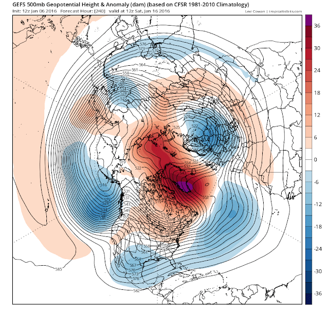
At this long of a range, we are just looking for large scale patterns. Individual shortwaves develop into snowstorms. Longwave troughs and blocking only ensures that shortwaves move into the right location to give us precipitation. Without a cold air source, there would be rain. Over the next two weeks, strong blocking is expected to develop and a trough is expected to settle over the eastern half of the US. Both major computer model suites the GFS/GEFS (ensemble) and the ECMWF(King Euro)/EPS (ensemble) show the blocking scenario. each suite consists of an operational model (full resolution) and ensemble runs, which are designed to randomly simulate slight variations in initial conditions to get a better handle on the confidence in the operational run's forecast. Ensemble means are also used at the medium to long range. After two weeks, the block shows signs of weakening. The GEFS shows less weakening than the EPS. However, with the strength of the block depicted, I am more inclined to go with a prediction that the block will stay since ridges of high pressure are famously hard to move (The Texas Death Ridge Ridiculously Resilient Ridge over California are two famous examples).
EPS (ECMWF Ensemble Forecast) for Jan 16 2016
GEFS (GFS Ensemble Mean) for Jan 16 2016

Since it's a Super-Nino, nothing is guaranteed. Without shortwaves, there will be no storms. Without cold air, it'll just rain. As stated previously, the pattern is changing. The pattern only shows potential. There can be bad luck or good luck. We have been let down by pattern changes before so although I remain cautiously optimistic, keep in mind that the we could very well just alternate between cold and dry and warm and wet. In my next post, I will talk about the couple of major threats that the models have seen.

