Saturday, January 11, 2014

Sunrise over Ian in the South Pacific...

Sunrise over Ian on 1/11/14

Satellite estimated intensity. Left scale is T# and right scale is the wind speed in knots that corresponds to the T#.  The higher the T# the higher the intensity estimate.
On a more random note: DirecTV wants to drop The Weather Channel...
http://www.washingtonpost.com/blogs/capital-weather-gang/wp/2014/01/11/weather-channel-urging-viewers-to-pressure-directv-not-to-drop-network/http://www.keeptheweatherchannel.com/

Friday, January 10, 2014

Ouch... Cyclone Ian strikes the Polynesian islands

Fiji Meteorological Services
Tropical Cyclone Advisory #24
SEVERE TROPICAL CYCLONE IAN, CATEGORY FOUR (07F)
12:00 PM FST January 11 2014
================================================= ==

At 0:00 AM UTC, Severe Tropical Cyclone Ian (938 hPa) located at 19.5S 174.4W has 10 minute sustained winds of 105 knots. Position good based on hourly multispectral enhanced infrared imagery and peripheral surface reports. The cyclone is reported as moving south southeast at 8 knots.

Hurricane Force Winds
======================
15 NM of the center

Storm Force Winds
==================
30 NM of the center

Gale Force Winds
================
60 NM of the center

Eye well defined on infrared only discernible on visible imagery. Eye warming and cloud tops cooling in past 6 hours. IAN lies in a low sheared environment just south of an upper ridge. Outflow enhanced to the south by jet stream located on the downstream side of the approaching upper trough. Sea surface temperature is around 28C. System is moving south southeastward on the southern periphery of the near-equatorial ridge to the north of the system.

Dvorak analysis based on eye pattern with warming eye in LG surround embedded in W yielding DT=6.0, MET=6.5, and PT=6.0. Final Dvorak intensity based on DT.

Dvorak Intensity: T6.0/6.0/D1.0/24 HRS

Global models agree on a south southeastward movement with gradual weakening.

Forecast and Intensity
========================
12 HRS 20.9S 173.7W - 90 knots (CAT 4)
24 HRS 22.5S 173.2W - 65 knots (CAT 3)
48 HRS 25.9S 172.3W - 50 knots (CAT 2)

Tropical Cyclone Watches/Warning for Tonga Island
================================================= 
A Hurricane Warning remains in force for the Va'vau group and Ha'apai group

A Gale Warning remains in force for the Tongatapu group

A Strong Wind Warning remains in force for the rest of Tonga Island


For those who don't understand what the text above is talking about...
Cyclone Ian-Category Four hurricane equivalent storm
10 min avg. sustained winds of 105 knots, 120mph
which translates to about avg. 1 min winds of 135mph
Central pressure: 938 millibars
This storm struck Tonga with winds around 105 mph, uprooting trees and damaging houses.
It is a very small storm, with hurricane winds extending only about 20 miles from the center and gale force winds extending only 70 miles from the center. In contrast, hurricane Irene had tropical storm force winds over a 500 mile swath.


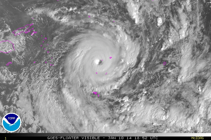
Ian making landfall on an island in the South Pacific 1/10/14
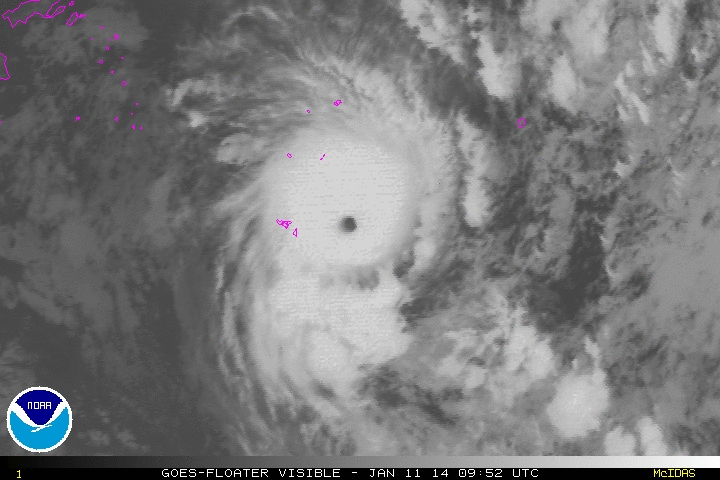
Ian at night 1/10-1/11/14

Thursday, January 9, 2014

Freezing Rain Advisory

A Freezing Rain Advisory is in effect for the DC area and points west from 3AM to 9AM. Surface temperatures are forecast to be in the upper 20's to low 30's. However, temperatures just a few thousand feet up will be well above freezing due to warm air overrunning the cold air wedge over our area. This warm air overrunning will create light precipitation. This will possibly lead to light ice accretion in the order of up to a 1/10 of an inch. A 2hr delay is possible tomorrow morning but not a given. Later in the morning, the temps will rise above freezing as the warm air travels northward and reaches pushes out the cold air ahead of a consolidating low pressure system to our west.
NWS total ice accretion forecast

Wednesday, January 8, 2014

Cold Air Damming

Cold Air Damming (CAD)
Cold air damming occurs when a cold low level air mass is locked into place due to topography. One place where this commonly happens is around here, the Mid Atlantic. High pressure to the north pumps cold air into the Mid Atlantic Region. This air jams up against the Appalachian mountains, creating an extension of the high pressure  along the Appalachian mountains .When a storm system arrives from the west, warm air overruns the cold, producing precip. Initially, the cold and dry air mass would cause any precipitation to evaporate, lowering the temperature of the air column through evaporative cooling, but eventually, precip will reach the ground. If the airmass is cold enough, the precip would be frozen.
Below is a graphic drawn from a model run depiction of a winter storm scenario, which demonstrates the cold air damming. The black arrows denote air flow from the arctic high to our north and the yellow lines show the isobars, which denotes a constant air pressure. Notice how a tongue of high pressure extends into the Mid Atlantic. Since the cold wedge is driven up against the mountains, precipitation over West Virginia is in the form of rain as the warm air advects (travels) northwards with the low and overruns the cold air. The mountains jut up into the warm air layer and as a result,  the precipitation is rain.


The precipitation should start out as a little snow. As the warm air  intrudes into the cold airmass at upper levels, the snow melts then refreezes forming sleet. As the warm air increasingly erodes the cold air, only a surface layer of cold air remains because warm air is less dense so it rises. Eventually, the cold air loses as a new low also forms to the east of the high pressure tongue. As a result, the cold northerly flow is cut off and replaced with warmer southerly and easterly flow.
The rate at which the cold air erodes is a major issue when forecasting. A difference of a degree or two could result in vastly different scenarios. Computer models tend not to do well with CAD events due to their low resolution.

Tuesday, January 7, 2014

Wintry mix early Friday morning?

After a truly arctic day, temps will drop once again into the single digits tonight. Both IAD and BWI broke daily low records and records for the lowest highs for the day. DCA did not break any daily temperature records. IAD had a low of 1 and  high of 18 while BWI had a low of 3 and a high of 16. DCA had a low of 8 and a high of 21 and the coldest mean temperature since 1996.
Iced over Potomac River on 1/7/14


Wednesday will feature highs in the upper 20s and lows int the lower 20s Southerly flow helps with the moderation of temperatures for the rest of the week into next week as the polar vortex lifts out. Thursday night into Friday morning is the next threat for wintry precipitation possibly starting out as snow and changing to light freezing rain. The storm's track and strength is still up in the air but it is likely that any precip will be light.


70 Hr Forecast by the CMC shows snow over the Midatlantic at 5AM Friday. 

Note the 1032 isobar (an isobar is just a line in delineating a certain air pressure and 1032 is a high pressure) jutting out over the region. This indicates possible cold air damming (CAD). Lows on Thursday night will be in the mid 20s while highs on Friday will rise above freezing to around 40. The light precip and nonexistent low pressure will work to prevent any major effects. However, this is only one solution and the actual outcome could be very different from what is depicted here. As the time frame draws closer, the details should begin to become clearer. At this point, all we know is that there is a threat for ice. Following that, a storm strengthens to our west, bringing temperatures into the 50s and heavy rain. A wet week after this one is supported by almost all model runs. However, the American Models (GFS and NAM) have had initialization errors for the past few days, meaning that their initial scenario does not match what is actually going on. This will lead to large errors for medium to long range forecasts. The NWS recommended that the runs be ignored outside of short term.
The 110 Hr forecast by the CMC shows a major rainstorm for the East Coast. The CMC is the weather model run by Canada.

Monday, January 6, 2014

Coldest air since 2013 errr... 1994


5:48AM Update
brrrrr.... It's 1.5 degrees here... cc..c.ccold..
11:30 PM Update
Temperatures have hit the forecast lows for the night at 6 degrees. There is still 7 more hours of cooling to go. Models continue to show temps near zero as a low tonight.

10:10 PM Update
DCA is running 6 degrees below forecast at 15  degrees. The forecast temperature for 10:00 was 21 degrees. 8.5 degrees at my house with a windchill of -7

7:04 Update
Random fact: DCA has dropped 6 degrees in the past hour to 26 degrees
Entering a very tight temp gradient.

ORIGINAL TEXT:
After a high of 49 at 7:52 AM at DCA,  the temps have plummeted following a passing cold front. Now this is a true Arctic Cold Front which is not something to be taken lightly. For the past 3 hours, the temperature at DCA has dropped 2 degrees per hr... That is some impressive cold air advection. The rapidly dropping temperatures combined with winds up to 35MPH have resulted in numerous windchill warnings and advisories across the area. Temps will continue to plummet tonight and early tomorrow morning to the single digits and quite possibly below 0 in the colder regions. Windchills will range from -10 to -20 at times. Tuesday highs will only be in the teens. However brutal the cold is, it will not last. Temperatures will moderate after tuesday for the rest of the week and a warmer, wetter pattern will emerge for the next week.

Temperature map at 5PM Monday shows that the cold air is on the side of the appalachian mountains and is trying to make it over.
The higher resolution short term models support the idea of brutal cold with temperatures going into the negatives for much of the DC area however, these temps may be slightly overdone. Nonetheless, it will feel really, really cold. I also think that the NWS temps might be slightly too high in the upper single digits around DC.

HRRR Model show 2m temps to be below 0 at 5AM Tuesday with time to go before sunrise.
The RAP model also shows temperatures below 0 at 5AM tuesday morning. Since sunrise is still 2.5 hrs away, the temperature will likely drop more than this.

The RAP model at 7AM tuesday morning. The 0 degree line is just south of DC
The RAP model temp forecasts have been running about 1 degree C below average for the East signalling the potential for colder than expected temps.


The cold windchill factors have prompted school closures and delays throughout the area, with 2 exceptions, DC public schools and Montgomery public schools. I think this is a very hazardou moves by the Mcps. At least DC is located in an urban heat island and is offering to open the schools early to let in the children from the Cold. Mcps is only on the other side of the river from Loudoun County, which has closed schools. However,  they are at a higher elevation.  Making students wait for buses in the 0 degree cold is not exactly safe. I hope they realize this and revert to a 2hr delay or a closing. (obviously as one of the students who have to ride the bus tomorrow I would think this... )