Wednesday, January 21, 2015

January 25-27 Possible Storm

I have been hearing many people talking about a snowstorm on Monday but not a mention of Friday's storm. Apparently people don't care about weekend snow. Anyways, here's what I think of the Monday time frame- too far out to tell for sure, but not looking so hot at the moment.

The best case scenario is a Miller B system, where a parent low weakens and redevelops a secondary low off the coast. The secondary low rapidly strengthens, bringing precip to the region. Typically, the reformation takes place too late because the parent low approaches too far to the north. In order for us to cash in on a Miller B, the parent low needs to be quite strong in order to "dig" far enough south for the storm to reorganize before it gets to us.

Models have been trending away from a snowy scenario towards a weaker, more northerly low.
4 successive GFS runs showing the storm at the same time period (7AM Monday). 00Z is the oldest and therefore the farthest south. 18Z is the most recent and the farthest north, illustrating the northward trend.
That being said, many things can change. After all, we are still very far away from the actual event. It took 6 runs to get from a storm that was so far south that it gave us nothing to a storm that is too far north. It can easy swing back. Fluctuations will probably diminish after the Friday-Saturday storm so we will wait until then to see. Don't let your hopes run too wild.

Thanks for reading, Alex

January 23-24 Coastal Storm

With out little snow surprise out of the way, we turn to our next potential storm, which is forecast to impact the area Friday to Saturday. Once again,  it will be an marginal event. Seeing how we over performed today and during the last event, we may be able to eke out a decent storm.

Summary:
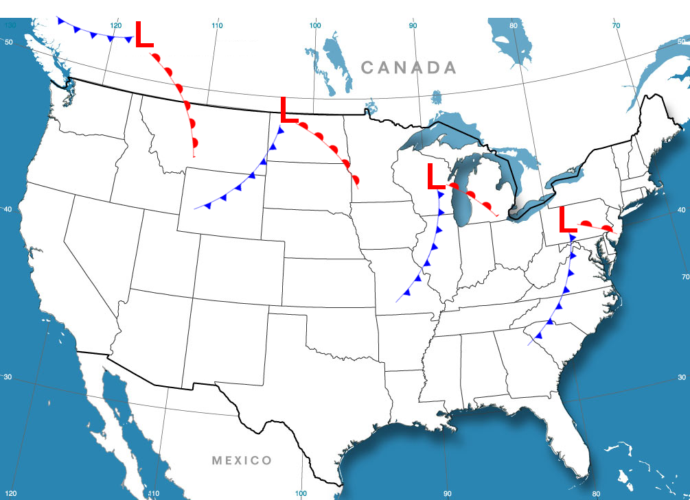
A shortwave trough over the southwest is expected to spawn a surface low in the Gulf of Mexico as it moves east.  As the storm strengthens, it is expected to turn north, passing near the Outer Banks of North Carolina, and strengthen as it heads NE out to the North Atlantic. This storm will bring precipitation, possibly heavy, to the region. Precipitation type has yet to be determined due to the lack of cold air and uncertainties in storm track and strength.


Our future coastal storm traversing the Southwestern US (Nevada, Arizona, New Mexico area) this morning

Discussion:
This storm will be very moisture laden, drawing up warm, moist air from the Gulf of Mexico and traveling north along the subtropical jet stream. These storms are know as Miller A type storms, and are well known for dropping high amounts of precipitation across the East Coast. Miller A snowstorms usually bring heavy, wet snow, just like the first storm of February 2010. This storm will not be as epic as that one though. However, this storm will be amped up, with pressures dropping possibly into the upper 980s ( about the pressure of a category 1 hurricane) by the time the storm starts pulling away.

The three ingredients for snow are cold, lift, and moisture. We have the moisture and lift, but cold will be marginal. Since we will lack a high pressure to the north, cold air will be residual. However, two possibly three things will benefit us. One is the presence of moderately cold air before the storm, the second is the midnight start time. There will be no daytime heating to deal with. The third is if the precipitation is heavy enough, dynamic cooling, will cool the air column. Temperatures are expected to be in the low 30s, but can change depending on storm strength and track.

Storm track and strength will affect temperatures both at the surface and aloft. Often, stronger coastal storms with a similar track will draw in warm air aloft, causing snow to mix or change over to sleet and or rain along the I-95 corridor. Mixing would majorly cut back on snow totals. Still worse is a track that is too far west, which draws even more warm air in, causing the storm to be all rain for us. As of now, it seems that the precipitation will at least start off as snow before mixing or changing over. Exact durations of frozen and liquid precipitation has yet to be resolved.

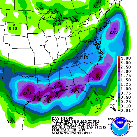
HPC preciptation forecast
Secondary to our worries about storm track and temperature is how much stuff will fall out of the sky. We currently expect between .5 and 1 inch of precipitation. How much is rain or snow is yet to be known.


Summary:
In a marginal situation like this,  many things can change in an instant. A couple of miles here and there can result in big changes. There is still a lot of model disagreement over precip timing, and amounts and storm track and strength. Maybe we rely on them too much. In any case, snow is possible Friday night into Saturday, and if not, it'll probably be rain. A complete miss seems unlikely.


Updates will come as warranted.
Thanks for reading! 
-Alex

Tuesday, January 20, 2015

Bit of wet snow tomorrow?

We are entering a pattern dominated by the polar jet stream (northern stream). Every 2-3 days we will have a chance at a low pressure passage. Not every one of these will result in snow but we certainly have many chances for at least the next 2 weeks. The first chance is tomorrow. A clipper is forecast to travel overhead and begin to redevelop off the coast. Temepratures will be marginal for a coating of snow. The National Weather Service has issued a Winter Weather Advisory for 1-3 inches of snow tomorrow morning into the afternoon.

...WINTER WEATHER ADVISORY IN EFFECT FROM 6 AM TO 6 PM EST
WEDNESDAY...

THE NATIONAL WEATHER SERVICE IN BALTIMORE MD/WASHINGTON HAS
ISSUED A WINTER WEATHER ADVISORY FOR SNOW... WHICH IS IN EFFECT
FROM 6 AM TO 6 PM EST WEDNESDAY.

* PRECIPITATION TYPE...SNOW.

* ACCUMULATIONS...1 TO 3 INCHES. LOCALLY HIGHER AMOUNTS POSSIBLE.

* TIMING...SNOW IS EXPECTED TO DEVELOP EARLY WEDNESDAY
  MORNING...AND CONTINUE THROUGH THE DAYTIME ON WEDNESDAY. THE
  HEAVIEST SNOW IS EXPECTED FROM LATE MORNING THROUGH MID AFTERNOON.

* TEMPERATURES...IN THE LOWER TO MID 30S.

* WINDS...EAST 5 TO 10 MPH.

This is not like last time's clipper (our snowday) temperatures will not be in the 20s but instead in the low 30s. Liquid to snow ratios won;t be so good, and with only .1-.2 inches of liquid forecast, 1 inch of snow may be hard to come by. Might just end up being wet rain.

Timing of the precipitation is also an issue. The models have been slowing down the arrival of the precip, not beginning it until mid morning, basically negating the benefits of a delay. A school day off would be possible, but so would an early release since the worst part is expected to be when schools usually let out. That being said, the southern part of the county should have a hard time getting snow to accumulate on the roads due to high temperatures possible mixing with rain or sleet. Our school situation all depends on how much the northern half of the county gets.

Accumulation: slush -1 inch

Prediction: School as usual tomorrow (50%)
Chances of:
  • Delay only-10%
  • Early Release-20%
  • Delay and closing/Closing only-20%

As I said, 2-3 days until the next storm. We're looking at Friday. Could be real fun or a super-soaker rainstorm. Time will tell.


Sunday, January 18, 2015

2 Week Snow (or not) Outlook


With meteorological winter is halfway through, it seems that the general consensus among snow lovers is that winter so far is lacking. It seems that many of the storms "cut" to the west of us, often timed with the retreat cold air, bringing us a cold rain. Whenever we have the cold, storms are suppressed and the precipitation is unable to reach us. The only victory we have gotten so far is an relatively strong clipper which dropped far enough south to drop us 3-4 inches of cold powdery snow.
Map of sample clipper track and frontal progression
According to a 2005 study, only 10% of clippers track south of the Great Lakes, so that was our lucky shot and hopefully not the last. Overall, our winter is not going bad at all considering the torch we called December. Average January and February snowfall is around 6 inches for both months. We can expect at least a decent chance at reaching average. The key would be to break out of our pattern and to slow down our storms with blocking.


There are established correlations between the positioning and strength of various semi-permanent atmospheric features around the world. Two such examples are the Azores High and the Icelandic Low. The North Atlantic Oscillation (NAO) looks at the difference in pressure between these two features. The NAO is correlated to the strength of the westerlies and the jet stream going across the North Atlantic. The NAO forecast is useful for predicting cold outbreaks across the eastern US. The jet stream serves as a fence holding the arctic air back. A negative NAO index translates to a weakened jet stream which be begins to meander,dipping near the East Coast, bringing cold air.  A positive NAO goes with a strong jet stream, which keeps the cold hemmed in to the north. 

On a larger scale, the Arctic Oscillation accounts for the strength and therefore,  waviness, of the jet stream. NASA climatologist Dr. James E. Hansen explains why the AO is so closely watched. "The degree to which Arctic air penetrates into middle latitudes is related to the AO index, which is defined by surface atmospheric pressure patterns. When the AO index is positive, surface pressure is low in the polar region. This helps the middle latitude jet stream to blow strongly and consistently from west to east, thus keeping cold Arctic air locked in the polar region. When the AO index is negative, there tends to be high pressure in the polar region, weaker zonal winds, and greater movement of frigid polar air into middle latitudes."
The AO is forecast to go negative for a few days before rising back to neutral. The forecast after a week is uncertain, as evidenced by the model spread.


 Last year, we lacked a negative AO but every time we had a snow event, the AO dropped for that period of time. The dip in the AO this week is accompanied by a chance of a storm.
The NAO is not forecast to go negative, which shows that it is not likely that there will be any significant storms.
 Apart from the NAO and AO, there are other indices that can signal potential patterns including the PNA and EPO, but enough talk about these. They only indicate if the pattern is ripe for storm and snow. Storm systems need to take advantage of the environment.

The pacific jet stream splits into the polar jet and the subtropical jet as it enters North America. Currently, the southern jet stream is dead. Our weather will be dominated by northern stream systems for the foreseeable future. The subtropical jet has been weak for quite a while. Our snow has been coming from northern stream systems. Models seem to be spitting a clipper towards us every 48 hours or so. Most will track to our north though some of them look interesting, dipping into our region. Some also show Miller B coastal storms, which is when a low, such as a clipper develops off the coast. However, due to the small distances between each storm system, we cannot say anything past the first one. Each system is already being affected by the next.

 The pattern should be improving for storms as we head towards the end of January. However, this pattern is also very hard to forecast. Nothing will be a lock until the event is within 48 hours. On a lighter note, we have a decent shot at scoring one or two snow events out of this pattern. The next chance is Wednesday. Stay tuned.