Over the past week, it has snowed almost every day, which has been just awesome. This is one of the reasons I like Ithaca. Ithaca averages between 60 and 70 inches of snow a year, although this year (and last) have been rather snow deprived. In addition, snowfall amounts vary greatly between the city central and the outlying areas due to elevation. Earlier during the winter, when it was warmer, I observed that the Animal Science area of campus would have snow accumulation while downtown would be just wet. I bet there probably is also the urban heat island effect at work too. But when it does snow (and stick), it provides a pretty scene.
So far, much of the snow has come from lake effect snow bands and weak
low pressure systems called Alberta Clippers. My favorite snowflakes are what weather weenies call dendrites. Snowflakes actually come in many different shapes depending on the temperature and moisture available and dendrites are the mot beautiful of them all.
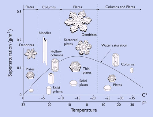
Dendrites are what a typical person imagines a snowflake to be. However, snowflakes are often not that shape. There are very specific conditions to the formation of dendrites and they are coveted by snow weenies for their beauty and their ability to accumulate quickly as very fluffy snow. Forming snow crystals is sort of like growing any other crystal. You have a seed where crystallization starts and slowly let the thing grow. The longer it stays the bigger and more complicated the crystal gets. With dendrites the optimal conditions are where temperatures in the cloud (called the snow growth region) are between -10 and -20 C and there is a relative abundance of moisture. Drier air results in thinner crystals and too dry results in needles as each of the arms break off. Too wet results in plates and thick snowflakes. It's all a balance.
 |
| Rather thick dendrite |
 |
| Thinner dendrites |
No matter what kind of snowflake falls, it's still pretty.
 |
| Looking at the East Ave. bridge over Fall Creek from the footbridge |
Another thing that many people don't realize is that larger snowflakes are mostly aggregates of small snowflakes. Dendrites love to lock arms due to all the nooks in crannies in their structure. Another way of getting aggregates to to be rimed (have liquid water) since the water will help with sticking to each other (and other things). The snow that fell this week were not rimed. They were dendrites, as the closeups below show.
 |
| Aggregate snowflake |
 |
| Many snowflakes |
 |
| Exiting NTRES 2201 into a flurry of dendrites |
 |
| Behind Mann |
 |
| Construction of stormwater retention ponds on the Ag Quad |
 |
| Temporary home of the Project Teams |
 |
| Frozen Beebee Lake |
Thus concludes my first place journal entry about the dendritic snowflakes of Ithaca. They are truely beautiful.
 |
| Just one more dendrite |


