Monday, August 24, 2015

Danny dies.. Erika about to form?

This morning, Tropical Depression Danny was downgraded to a remnant low. Wind shear and dry air has taken its toll on the storm. Although it still has convection, Hurricane Hunter aircraft indicated that the low level circulation has dissipated.
BULLETIN
REMNANTS OF DANNY ADVISORY NUMBER  25
NWS NATIONAL HURRICANE CENTER MIAMI FL       AL042015
1100 AM AST MON AUG 24 2015

...DANNY DEGENERATES INTO A TROUGH OF LOW PRESSURE...
...THIS IS THE LAST ADVISORY...

SUMMARY OF 1100 AM AST...1500 UTC...INFORMATION
-----------------------------------------------
LOCATION...16.0N 62.0W
ABOUT 45 MI...70 KM WSW OF GUADELOUPE
MAXIMUM SUSTAINED WINDS...30 MPH...45 KM/H
PRESENT MOVEMENT...W OR 275 DEGREES AT 12 MPH...19 KM/H
MINIMUM CENTRAL PRESSURE...1010 MB...29.83 INCHES
 
DISCUSSION AND 48-HOUR OUTLOOK
------------------------------
Reports from an Air Force Hurricane Hunter plane indicate that Danny
has degenerated into a trough of low pressure.  At 1100 AM AST (1500
UTC), the remnants of Danny were located near latitude 16.0 North,
longitude 62.0 West.  The remnants are moving toward the west near
12 mph (19 km/h), and this general motion is expected to continue
for the next day or two.

Maximum sustained winds have decreased near 30 mph (45 km/h) with
higher gusts.  The trough is expected to dissipate during the next
couple of days.

The estimated minimum central pressure is 1010 mb (29.83 inches).

HAZARDS AFFECTING LAND
----------------------
RAINFALL: The remnants of Danny are expected to produce 2 to 4
inches of rain over the Leeward Islands, the U.S. and British Virgin
Islands, Puerto Rico, and the Dominican Republic through Tuesday
night.

NEXT ADVISORY
-------------
This is the last public advisory issued by the National Hurricane
Center on Danny.  Additional information on this system can be found
in High Seas Forecasts issued by the National Weather Service, under
AWIPS header NFDHSFAT1, WMO header FZNT01 KWBC, and available on the
Web at http://www.opc.ncep.noaa.gov/shtml/NFDHSFAT1.shtml.
$$
Forecaster Pasch 
 
Ex-Danny should bring some much needed rain to Puerto Rico and the Northern Lesser Antilles, which are in a drought. The dry air and high shear have prevented storm from bringing much needed rain and these islands also receive a substantial amount of their summer precipitation from tropical waves and cyclones.
Radar Loop out of Puerto Rico showing the remnants of Danny approaching the island

Another tropical wave that moved off of Africa a few days ago, dubbed Invest 98L, has been steadily organizing. Although it has tropical storm force winds, a closed circulation has not been confirmed. The NHC gives it a 90% chance of developing. All it has to do is close off the west side of its circulation to be classified as Tropical Storm Erika and since it is in an area with moderate shear, warm sea surface temperatures, and little dry air and dust, it shouldn't be too hard to do.
CMISS Wind Shear analysis of the Tropical Atlantic. Invest 98L is on the lower right near the spiral which depicts an upper level high, which will help ventilate the storm.
A recent scatterometer pass caught half of the circulation, which appears to be elongated. It also caught tropical storm force winds.


TROPICAL WEATHER OUTLOOK
NWS NATIONAL HURRICANE CENTER MIAMI FL
800 PM EDT MON AUG 24 2015

For the North Atlantic...Caribbean Sea and the Gulf of Mexico:

1. Thunderstorm activity associated with a low pressure system located
about 825 miles east of the Lesser Antilles has become a little
better organized today, although satellite wind data today suggest
that the system has not yet developed a fully closed surface
circulation.  Recent reports from a NOAA buoy indicate that the low
is producing winds to tropical-storm-force, and only a small
increase in organization would result in the formation of a tropical
storm as the system moves westward near 20 mph.  Interests in the
Leeward Islands should monitor the progress of this disturbance.
Additional information on this low can be found in high seas
forecasts issued by the National Weather Service.
* Formation chance through 48 hours...high...90 percent
* Formation chance through 5 days...high...90 percent
 
Some models, namely the specialized high resolution hurricane forecast models, GFDL and HWRF strengthen the storm significantly.  Current models bring the storm north of the Caribbean islands by the end of the week. As the storm approaches the US, where it goes will be less certain. The storm could go out to sea or it could be pushed west into the US by the Bermuda High. It is probably a good idea to keep an eye on this storm.

Whole view shot of the Caribbean and western Tropical Atlantic. Ex-Danny is the yellow blob in the middle and Invest 98L (future TS Erika) is the red and yellow blob on the right.

Sunday, August 23, 2015

Active Tropics: Atsani, Danny, Loke, Kilo, Goni, and Invest 98L

We're approaching the peak of Tropical Cyclone formation in the Northern Hemisphere. Due to the strengthening El-Nino, (technically not declared yet but will be next month) the Pacific basin has been in hyperdrive while the Atlantic has been relatively quiet (I emphasize relatively).

The West Pacific
Twin typhoons, Atsani and Goni are spinning in the West Pacific. They were named within hours of each other.
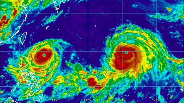
Goni on the left, Atsani at peak strength on the right. Image taken 8 19 2015
17W: Typhoon Atsani
Atsani has been the sronger of the two, developing faster and attaining supertyphoon status on ___ . The storm has since weakened and is undergoing the transition to an extratropical storm in the North Pacific. It has not impacted land and has weakened to a minimal typhoon
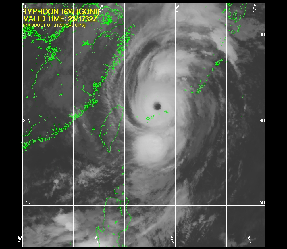


16W: Typhoon Goni
Goni took a more westerly route, heading for the Philippines before making an extremely sharp turn to the north and paralleling Taiwan's coastline. Although the storm's core has not impacted major landmasses yet, the outer bands caused flooding in the Philippines resulting in 10 deaths (source). Goni underwent a major spurt of intensification today to a Category 4 typhoon with winds of 135 MPH before hitting the southernmost islands of Japan.
Goni is forecast to weaken as it shoots the gap between South Korea and Japan, taking a unusual path towards the NW as it weakens. Normally recurving storms would turn NE. High winds and heavy rain is expected in the southern islands of Japan and possibly in Korea too.
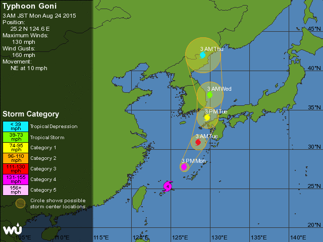
The future track of Typhoon Goni goes right between Japan and South Korea
Typhoon Goni is a long track typhoon. Note the extremely sharp turn near the Philippines.
The Central Pacific
03C Tropical Depression Kilo
Kilo has had issues with organization. Originally forecasted to impact the western part of the Hawaiian island chain at hurricane strength as it was hooked north by a abnormally strong trough of low pressure, the  storm is heading west as a weak tropical depression and is forecasted to stay away from the islands as it turns north. It is forecasted to strengthen due to unusually warm waters and low shear.

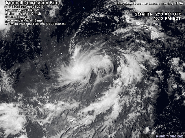
Satellite Imagery shows modest and disorganized thunderstorms over Kilo

04C Tropical Storm Loke
Tropical Storm Loke is forecasted to be absorbed by the extratropical remnants of Tropical Storm Atsani. It is forecast to peak as a strong tropical storm and is currently NW of Hawaii and will not affect any land.

Loke is heading out to sea. TD Kilo is visible at the bottom right of the image.


The Atlantic Basin
This is sort of the runt of all the basins. The storms here are no match to the monsters in the W Pacific

04L Tropical Storm Danny
Danny, the first Major hurricane of the Atlantic Hurricane Season, has succumbed to high windshear and dry air. It has only disorganized convection displaced NE of it's low level center. The most recent Hurrican Hunter flight failed to find winds supportive of anything more than a Tropical Depression near the LLC. However, computer models have had more enthusiasm with restrengthening this tenacious storm as it tracks through the NE Caribbean.

Danny had overcome dry air to strengthen to a major hurricane but the shear was just too much for him. The storm has stayed south of forecast points for a while so no one's really sure where it's going to go. It it his the islands, the circulation could be destroyed and Danny would be no more. It it somehow stays on water it could restrengthen.Right now, the global models call for the dissipation of Danny.
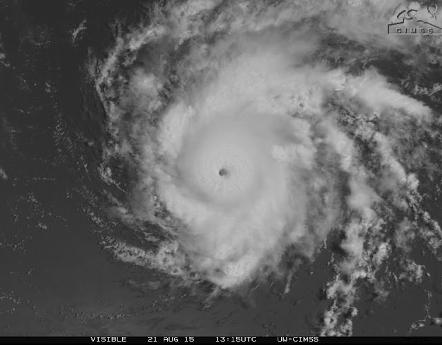
Danny at peak strength on August 21 2015 with sustained winds of 115 MPH and a well defined, but tiny, eye

Although models depict redevelopment, the official forecast calls for continued weakening and eventual dissipation
Invest 98L 
The next of a line of tropical waves to come of of Africa,  It has maintained decent convection and vorticity for a couple of days now and computer models forecast the storm to strengthen possibly to hurricane strength as it passes north of the Caribbean islands. The National Hurricane Center gives it 70% chance of developing into a TD within the next 48 hours and 80% over the next 5 days. 
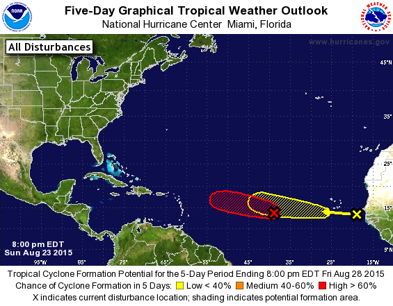
The red oval is the area 98L is forecasted to develop into a depression.

The HWRF model (which did quite well with Danny) forecast for 98L on August 29th calls for the storm to be a strong hurricane north of the Caribbean islands.
Recent scatterometer passes have indicated that it does not have a completely closed circulation yet although it has TD strength winds. It is also lacking a bit in convection, although not as much as ailing TS Danny.


My patch of succulents, two years gone

The whole "rock garden" was built upon a part of a old stump  since grass just would not grow there. The garden has been there for 2 years and has changed a lot. No soil amendments were done, not that there was much soil to begin with. The Hens and Chicks got the worst site, 1 inch of clay on top of rotting wood. the other two plants were positioned just outside the stump with more root space. The Hens and Chicks didn't mind the inconvenience of growing on wood but the others were turned to mush by our winter.
This is what it looked like 2 years ago right after planting. The cactus and agave were both turned to mush by 0 degree temps that winter.
The following spring, I planted some sedums to replace the dead plants. I found one of the sprigs under a bird nest. A bird presumably too it from my neighbor's patch of sedums to put into the nest but it fell out. Half the plot has been taken over by Black Eyed Susans which seeded itself there.
 
The Hens and Chicks managed to flower this year and look pretty cool. The garden is located within 2 feet of the road and seems to be unaffected by salt in the winter. I hope to continue expanding the garden into the surrounding grass since the stump is about 5 feet wide and none of the grass there does very well.


Hens and Chicks
Dwarf blue sedum
Some sedums that birds brought over

It's been a nice summer

Winter was brutally cold.. or not... not really... I bottomed out at -2 degrees... I'm in zone 7, so minimum lows near 0 are expected on average. In any case, some of the plants I had outside perished while others were set back. Thankfully we had a warm spring, and a decent, but not brutally hot summer. There were times in which it even seemed to be a bit cool. The plants loved this summer. Without further ado, I present the Maryland Tropics, Year 8, Summer 2015.


The  Musa Basjoo  was frozen to the ground despite a protective wrapping of burlap and Christmas lights. The week of 20 degree highs and single digit lows probably did it in. In any case, the plant resprouted in late April and came back with a vengeance. This is all the growth in the past 4 months.


Lord Baltimore Hibiscus,Very vigorous grower with hundreds of flowers a year. Seems less prone to dropping buds during dry weather than the others I've grown.


Newly planted Raspberry
Seedling Poncirus trifoliata (Trifoliate Orange)

Variegated ginkgo seedling that I found. I hope it remains stably variegated

Banana Pups
Caynne Pepper Plant


Ginger plant sprouted from a piece from the supermarket
Entrance to the backyard

Seed grown Canna indica with some caladiums
Cannas, Caladiums, and gingers
Mass of Purple Coneflowers and Black Eyed Susans

Dahlia, unknown variety