This is my snow map. It is completely experimental and we shall see how it turns out. It is significantly higher than the NWS map but is in line with model predictions.

7:00 PM UPDATE:
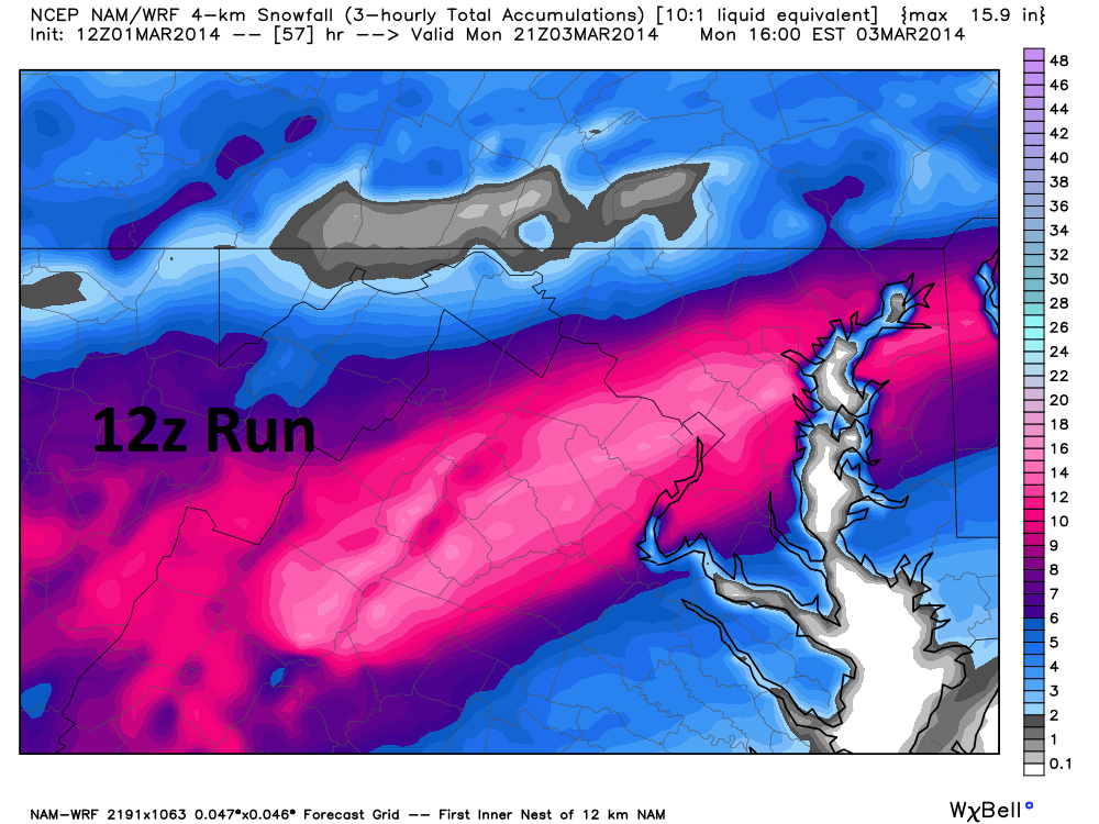
It looks like the NWS forecast is going to bust too low. This storm is amped up over the plains, it's not going to go too south. Only the NAM supports that now. Even all 22 members of the SREF model suit give us at least 6 inches of snow. that is the first time I have seen that happen before. Go home NAM, you're drunk. The other models including the short range RAP and HRRR are getting into range and they so far have kept the storm farther north. So has the 18Z GFS giving us 8-10 inches.
 |
| 18z GFS |
 |
| SREF for DCA. Bolded black line is mean of the 22 model outputs |
http://www.montgomeryschoolsmd.org/
http://www.opm.gov/
4:00 PM UPDATE:
The previous forecast map is now invalid. The NWS has lowered snow totals, dropping the bullseye way to the south. This I do not agree with. I do agree that the previous map was too bullish but I think the bullseye of the snow still should be around DC albeit lower, say 8-10 inches with isolated areas of 10+ just to the south of the city. Most models have dropped south, due to a stronger cold front. However, all except for the NAM give us some decent snow. Only the NAM almost shuts us out, even then, that is 3-5 inches of snow. The NAM has issues, primarily because it initialized the low too far south, affecting the whole run.
The winter storm warning was lowered to 4-8 inches of snow.
...WINTER STORM WARNING REMAINS IN EFFECT FROM 7 PM THIS EVENING
TO 6 PM EST MONDAY...

* PRECIPITATION TYPE...FREEZING RAIN...SLEET...AND HEAVY SNOW.

* ACCUMULATIONS...UP TO ONE TENTH INCH OF ICE...FOLLOWED BY 4 TO
  8 INCHES OF SNOW.

* TIMING...RAIN CHANGES TO FREEZING RAIN AND SLEET FROM NORTH TO
  SOUTH THIS EVENING THEN BECOMES HEAVY SNOW LATE TONIGHT THROUGH
  MONDAY.

* TEMPERATURES...FALLING INTO THE LOWER 30S THIS EVENING...THEN
  DROPPING INTO THE LOWER 20S OVERNIGHT AND MONDAY.

* WINDS...NORTH 10 TO 15 MPH. GUSTS TO 25 MPH LATE TONIGHT AND
  MONDAY.

* IMPACTS...HAZARDOUS TRAVEL DUE TO ICE AND SNOW THROUGH MONDAY.
  BOTH THE MONDAY MORNING AND AFTERNOON RUSH HOURS WILL BE
  AFFECTED. POWER OUTAGES ARE POSSIBLE WITH THE COMBINATION OF
  ICE AND HEAVY SNOW.
The NEW NWS map:

The original maps are now invalid.
ORIGINAL TEXT:
This winter just gets better and better. First, we got our 3-6 inch storms and looked in sadness as the same storms dropped upwards of a foot and a half farther north. Redemption came withe the 2-13 storm, but that had temp issues at the end. Now here we are, at the beginning of march, staring down at another major storm.
This storm has not been without it's drama. All the models had different solutions until last night. I was worried about this until this morning, when the models were finally in line with giving us the hit. The NAM, a short term models, was the most disturbing, dropping the snow mostly to the south. The GFS had a slightly southerly solution, and the Euro (ECMWF) was mostly consistent with dropping snow over us but had a few blips. The Canadian short term (RGEM) and global model (CMC/GEM) both were very consistent with painting the snow stripe across the DC area. Kudos to them...
 |
| The NAM kept shifting south... But has since joined the rest of the models in giving us some snow... |
THE NATIONAL WEATHER SERVICE IN BALTIMORE MD/WASHINGTON HAS
ISSUED A WINTER STORM WARNING FOR HEAVY SNOW...SLEET...AND
FREEZING RAIN...WHICH IS IN EFFECT FROM 7 PM THIS EVENING TO 6 PM
EST MONDAY. THE WINTER STORM WATCH IS NO LONGER IN EFFECT.

* PRECIPITATION TYPE...FREEZING RAIN...CHANGING TO SLEET...AND
  THEN HEAVY SNOW.

* ACCUMULATIONS...AROUND ONE TENTH INCH ICE...THEN 8 TO 12 INCHES
  OF SNOW.

* TIMING...FREEZING RAIN AND SLEET WILL BEGIN THIS EVENING WITH
  HEAVY SNOW LATE TONIGHT THROUGH MONDAY.

* TEMPERATURES...DROPPING FROM THE LOW 30S THIS EVENING TO THE MID
  20S OVERNIGHT...THEN LOW 20S THROUGH MONDAY.

* WINDS...NORTH 10 TO 15 MPH WITH GUSTS UP TO 25 MPH.

* IMPACTS...VERY HAZARDOUS TRAVEL THIS EVENING TROUGH MONDAY...
  AFFECTING BOTH THE MONDAY MORNING AND MONDAY AFTERNOON PEAK
  COMMUTE HOURS. POWER OUTAGES ARE POSSIBLE WITH THE COMBINATION
  OF ICE AND HEAVY SNOW.
Their snowfall map gives DC and the surrounding suburbs the bullseye, with 10-14 inches of snow.

The point forecast for southern MoCo is very interesting...
- TodayRain, mainly after 4pm. High near 48. Light and variable wind becoming northeast 6 to 11 mph in the morning. Chance of precipitation is 90%. New precipitation amounts of less than a tenth of an inch possible.
- TonightRain before 1am, then freezing rain and sleet between 1am and 4am, then snow after 4am. The snow could be heavy at times. Low around 22. North wind 11 to 15 mph. Chance of precipitation is 100%. New ice accumulation of less than a 0.1 of an inch possible. New snow and sleet accumulation of 1 to 3 inches possible.
- MondaySnow. The snow could be heavy at times. Some thunder is also possible. High near 24. North wind 11 to 16 mph. Chance of precipitation is 100%. New snow accumulation of 7 to 11 inches possible.
- Monday NightSnow likely before 7pm. Cloudy during the early evening, then gradual clearing, with a low around 5. Wind chill values as low as -2. North wind 6 to 11 mph. Chance of precipitation is 60%.
No school tomorrow... 95% sure, Thanks for reading!
-Alex